The archaeological site of Santa Maria di Nabui is located about 20 km north of Guspini, along the road that leads to the seaside resort of Torre dei Corsari, through the town of Sant'Antonio di Santadi. It is located in a narrow alluvial plain, bounded to the south by a hilly area to the north by the Sa Salinedda pond and the southernmost of the Santa Maria ponds.
Located about 20 km north of Guspini, the ruins of the site called “Santa Maria di Nabui” are located in an alluvial plain whose land has been reclaimed to facilitate the establishment of agricultural activities that have been carried out in the area for centuries.
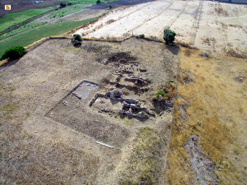
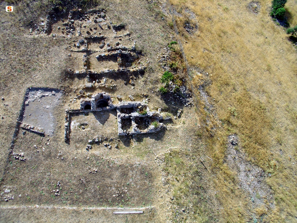
InHABITED SINCE THE NEOLITHIC AGE, IT BECAME THE SITE OF A TRADING PORT AS EARLY AS THE FINAL BRONZE, TO BE TRANSFORMED INTO AN EMPORIUM BY THE PHOENICIANS AND FOUNDED AS A CITY BY THE PUNICS OF CARTHAGE. In the Roman Age, the commercial vocation of the center continued, strategic for the trade of cereals and metallic resources coming from the hinterland: the remains of housing structures, an aqueduct, a road route and thermal baths are still visible. The continuity of life of the inhabited center is still attested for centuries: in the Cosmography of the Anonymous Ravenna Neapolis is mentioned among the civitates of the island of Sardinia. In particular, part of the thermal building built with the opus caementicium technique and external and internal walls in opus vittatum mixtum with brick wall edges, whose construction dates back to the Late Imperial Age (II-III century AD), located in the south-eastern sector of the ancient city, was reused until the 18th century as a church dedicated to the Virgin of Santa Maria de Nabui. The building for Christian worship was built using a spacious rectangular thermal environment, vaulted in a barrel. On the occasion of this intervention, a large rectangular opening placed on the short side of the room was plugged in. The structure, which has been heavily damaged and has undergone recent consolidation and restoration work, has been raised for about 3.1 m., while some portions of the original floor remain. The internal walls have traces of plaster on which graffiti and christological monograms are still visible, traced back to the use of the environment as a religious building. In the current state of archaeological research, it is not known precisely when the thermal building was transformed into a church of Christian worship: from some comparisons with similar Sardinian contexts, also subject to a change in the destination of thermal use (Sant'Andrea di Pischinappiù di Narbolia, Santa Maria di Vallermosa, Santa Maria di Mesumundu, sanctuary of Our Lady of Bonacattu in Bonarcado), the passage would seem to be able to be placed in the early Middle Ages or in the Vandalic Age at the latest.
The church appears to have been in full operation until the 18th century: Christian rites were still celebrated there when it was banned by Monsignor Pilo, Bishop of Ales-Terralba, as it became a refuge for traffickers.
History of excavations and studies
The area of Neapolis has been known in literature since ancient times: Pliny the Elder, in the first century BC, in the third book of his Naturalis Historia, listed among the peoples and cities of Roman Sardinia, eighteen oppida, including some civitates stipendiariae inhabited by pilgrims (Sulci, Valentia, Neapolis, Bitia); it is mentioned as a coastal center by Ptolemy (III, 3, 2), which includes the city among the poleis of the western coast of the island of the island of Sardinia; moreover, its identification with the Neapolitanus portus, known from portolani and thirteenth century nautical charts, is now unequivocal, as well as the mention of Domo de Neapolis, referring to a modest rural village mentioned in documents around the middle of the thirteenth century, would seem to refer to this context.
The importance of the archaeological context was already evident in the 19th century when Vittorio Angius described the extension of the predominantly commercial settlement and the characteristics of the monumental emergencies.
Archaeological research in the area was started in the middle of the 19th century and resumed in 1951, but it was activated in an intense and almost continuous way from the Seventies of the last century until today.
Bibliography
R. Martorelli, The cities in Sardinia between late ancient and early medieval times, in S. Angiolillo, R. Martorelli, M. Giuman, D. Artizzu, Roman and Early Medieval Sardinia. History and materials, series “Corpora delle Antiquità della Sardegna”, Sassari 2017, pp. 265-278;
E. Usai, M. Casagrande, C. Oppo, L. Garau, A. Loy, P. G. Spanu, R. Zanella, R. Zucca, The landscape of city power in a Sardinian-Roman city: the “Great Baths” of Neapolis, in M. B. C., A. Gavini, A. Ibba (edited by), Roman Africa. Transformation of the landscapes of power in North Africa until the end of the ancient world. Proceedings of the XIX study conference. Sassari, 16-19 December 2010, Rome 2012, pp. 1905-1929;
P. G. Spanu, Byzantine Sardinia between the 6th and 7th centuries, series “Late Antique and Medieval Mediterranean. Excavations and research”, 12, Oristano 1998, pp. 56-58, 131-143;
P. G. Spanu, The urban structure of the Roman city, in R. Zucca (edited by), Splendidissima Civitas Neapolitanorum, Rome 2005, pp. 245-279; R. Zucca, Splendidissima Civitas Neapolitanorum, Rome 2005;
R. Zucca, Neapolis and its territory, Oristano 1987; C. Puxeddu, Romanization, in the Diocese of Ales-Usellus Terralba. Aspects and values, Cagliari 1975, pp. 165-221;
G. Spano, Description of ancient Neapolis, in “Sardinian Archaeological Bulletin, a collection of ancient monuments of all kinds from all over the island of Sardinia”, n. 9, Cagliari 1859, pp. 129-137.
How to get there
Take the SS 130 to the junction for Villasor and take the SS 196 that leads to Guspini. Once in the town, take the SS 126 up to km 94, where you turn towards Sant'Antonio di Santadi. From the fork, go about 15 km and turn off to a road of agrarian penetration. After about 200 m you are in the archaeological area.
Content type:
Religious architecture
Province: South Sardinia
Common: Guspini
Macro Territorial Area: South Sardinia
POSTAL CODE: 09036
Address: SP 65
Update
Where is it
Guspini, Chiesa di Santa Maria di Nabui Images number: 2
Images
Video
Audio


Comments