Subjects





The site is located in the southeastern part of the Gulf of Oristano and stands on a complex of alluvial ridges near the lagoon system formed by the Marceddì, San Giovanni, and Santa Maria ponds.
The area where the remains of the ancient city of Neapolis are located, inhabited since the Neolithic period, was continuously inhabited from the late Bronze Age until the 8th century, when an emporium was established by the Phoenicians. As part of their expansion into the Gulf of Oristano, which led to the founding of Othoca and Tharros, they settled on a site already inhabited by an indigenous population, giving it the status of a trading post. Subsequently, towards the end of the 6th century BC, the Carthaginians founded a city there to serve as a collection and sorting point for agricultural resources from Campidano and metals from the Montevecchio area, which were then shipped for trade.
The Roman phase of the city of Neapolis is well documented: thanks to the comb survey method, using aquatic, marsh, and land transects, according to the principles of landscape archaeology, it was possible to identify archaeological deposits that extend chronologically from the Archaic Age to the Imperial Roman period. These deposits, contained beneath the layer of mud deposited on a historical-era seabed, were located along a line approximately west-northwest/east-southeast within the San Giovanni lagoon, in relation to the creation of an embankment by the Department of Environmental Protection of the Autonomous Region of Sardinia.
The presence of a port at Neapolis is now a well-established fact among scholars: archaeological investigations have revealed fragments of amphorae within the San Giovanni lagoon that span a chronological period from the late 7th century BC to the 2nd century BC. C. of the same types were identified in a buried lagoon area located northwest of the urban area of Neapolis, testifying to the importance of the Neapolitan port for internal and Mediterranean trade at least since the Late Bronze Age, given the high percentage of artifacts of non-local origin.
During the Roman period, Neapolis continued its commercial vocation, as it had in previous eras, from the creation of the first emporium by the Phoenicians and its foundation as a city by the Carthaginians. The artifacts recovered in the urban and peri-urban area attest to the export of cereals, wine, and metals from the Montevecchio area.
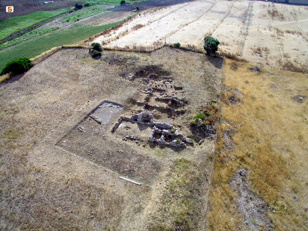
The excavations have uncovered the Roman-era road, built from basalt and sandstone blocks with an east-west orientation, dating to the 1st-3rd century AD, connected to residual structures presumably used for residential purposes. Along the road's northern edge, the remains of a water passage presumably connected to the sewer system remain.
The road, already described by Giovanni Spano, likely forms a section of the Via a Tibula Sulcis, one of the most important connecting routes in Roman Sardinia: it continued north toward Othoca, while to the south, after crossing the city of Neapolis, it connected to Metalla and the Sulcis region. According to Spano's interpretation, confirmed by recent studies, in addition to being a connecting road, its western bank served as a port pier, since it was connected to the commercial port "[…] at the foot of the city lies the pond called Santa Maria, at whose edge began the 7-meter-wide road, built with large slabs and now called the Ponti de is Damas. Here was the Portus Neapolitanus, which extended along the shore of the same pond, as the current ruins show […]". In the northwestern sector of what has been identified as the urban area of ancient Neapolis, the ruins of a cluster of orthogonal structures, oriented northwest/southeast and northeast/southwest, pertaining to public buildings, have been uncovered. Both during excavation campaigns and following previous fortuitous surface finds, this small area has yielded architectural elements such as capitals, column bases, entire columns, a statue base, a marble statuette belonging to Aphrodite Urania, fragments of other statues, mosaics, various types of marble, painted plaster, and inscriptions, some of which refer to emperors (the most notable cites a dedication to Emperor Valerian, placed at public expense by decree of the decurions of Neapolis). Archaeological investigations have also led to the discovery of urban baths located in the northern sector of the city of Neapolis. The monument features a series of quadrangular and apsidal rooms, which have subThe complex has undergone transformations over time: the apodyterium, the frigidarium (on the eastern back wall of which is a small apsidal pool accessible by three steps, while in the upper portion, a horizontal recess marks the opening of three rectangular niches topped by round arches, probably intended to house statues), a first calidarium (with a praefurnium on the western side still bearing traces of its use), a second calidarium (composed of a square room, connected to the south by a semicircular room, and equipped with a severely damaged praefurnium), as well as several service rooms, are still identifiable. Extensive research has revealed portions of the wall structures, preserved up to a maximum height of 40 cm, which were severely damaged by repeated agricultural work carried out in the area over the centuries. The walls, oriented northwest/southeast, with both sides covered in mortar plaster, partially patchy, appear to have been built using a "pseudo-frame" construction technique, using quadrangular sandstone blocks interspersed with sections filled with roughly hewn basalt stones of medium or larger size, carefully selected, and bound with earth. According to the most widely accepted interpretation, the wall fragments are attributable to buildings belonging to public spaces in the ancient Roman city of Neapolis.
History of Excavations and Studies
The Neapolis area has been known in literature since ancient times: Pliny the Elder, in the 1st century BC, in the third book of his Naturalis Historia, listed eighteen oppida among the peoples and cities of Roman Sardinia, including several civitates stipendiariae inhabited by pilgrims (Sulci, Valentia, Neapolis, Bitia); It is mentioned as a coastal center by Ptolemy (III, 3, 2), who includes the city among the poleis of the western coast of the island of Sardinia. Its identification with Neapolitanus portus, known from 13th-century portolans and nautical charts, is now unequivocal. The mention of Domo de Neapolis, referring to a modest rural village mentioned in documents around the mid-13th century, also seems to relate to this context.
The importance of the archaeological context was already evident in the 19th century, when Vittorio Angius described the size of the settlement, which was primarily commercial, and the characteristics of its monumental remains.
Archaeological research in the area began around the mid-19th century and resumed in 1951, but has been intensive and almost continuous since the 1970s until today.
Bibliography
P. Defrassu, Catalogo. 1.216 - Statua di Afrodite Urania, in S. Angiolillo, R. Martorelli, M. Giuman, D. Artizzu (a cura di), La Sardegna Romana e Altomedievale. Storia e materiali, collana "Corpora delle Antichità della Sardegna", Sassari 2017, p. 374;
A. Ibba, Catalogo. 2.5 - Iscrizione onoraria, in S. Angiolillo, R. Martorelli, M. Giuman, D. Artizzu (a cura di), La Sardegna Romana e Altomedievale. Storia e materiali, collana "Corpora delle Antichità della Sardegna", Sassari 2017, p. 388;
A. Mastino, La Sardegna al centro del Mediterraneo, in S. Angiolillo, R. Martorelli, M. Giuman, D. Artizzu, La Sardegna Romana e Altomedievale. Storia e materiali, collana "Corpora delle Antichità della Sardegna", Sassari 2017, pp. 17-32;
S. Atzori, La viabilità romana nella Provincia di Oristano, Mogoro 2010, p. 134;
P. G. Spanu, R. Zucca, Il Neapolitanus portus alla luce delle ricerche di archeologia subacquea, in A. Mastino, P. G. Spanu, R. Zucca (a cura di), Naves plenis velis euntes, Collana del Dipartimento di Storia dell'Università degli Studi di Sassari, 36, Roma 2009, pp. 217-235;
A. Mastino, P. G. Spanu, R. Zucca, Mare Sardum: merci, mercati e scambi marittimi della Sardegna antica, Collana del Dipartimento di storia dell'Università degli studi di Sassari, 26; Tharros Felix, Roma 2005;
G. Ranieri, Indagini geofisiche a Neapolis, in R. ZUCCA (a cura di), Splendidissima civitas Neapolitanorum, Roma 2005, pp. 232-244;
P. G. Spanu, L'impianto urbanistico della città romana, in R. Zucca (a cura di), Splendidissima civitas Neapolitanorum, Roma 2005, pp. 245-279;
R. Zucca, C. Cossu, Le officine scrittorie dei Neapolitani, in R. Zucca (a cura di), Splendidissima civitas Neapolitanorum, Roma 2005, 195-227;
R. Zucca, Splendidissima civitas Neapolitanorum, Roma 2005;
P. G. Spanu, La Sardegna bizantina tra VI e VII secolo, collana "Mediterraneo tardoantico e medievale. Scavi e ricerche", Oristano, S'Alvure, 1998, pp. 56-58;
F. Fanari, L'antico porto di Neapolis-Santa Maria di Nabui-Guspini (CA), in "Quaderni della Soprintendenza per le Province di Cagliari e Oristano", 6-1989, pp. 125-138;
R. Zucca, Neapolis e il suo territorio, Oristano 1987;
G. Spano, Descrizione dell'antica Neapolis, in "Bullettino Archeologico Sardo ossia raccolta dei monumenti antichi di ogni genere di tutta l'isola di Sardegna", n. 9, Cagliari 1859, pp. 129-137;
V. Angius, sv. Guspini, in G. Casalis, Dizionario geografico storico-statistico-commerciale degli Stati di S.M. il Re di Sardegna, VIII, Torino, G. Maspero, 1841.
Getting there
Take the SS 130 until the turnoff for Villasor and then take the SS 196 to Guspini. Once in the town, take the SS 126 until km 94, where you turn left towards Sant'Antonio di Santadi. From the turnoff, travel about 15 km and turn right onto a farm road. After about 200 meters, you'll find yourself in the archaeological area.
Update
Images
Video


 Facebook
 Twitter
 LinkedIn
 Whatsapp

 Print
Print
 E-mail


Comments