Subjects





The search for the temple of Sardus Pater was the most exciting question of the ancient topography of Sardinia.
In the 16th century, the codes and the first printed books by Greek and Latin authors began to circulate again on the island. A lively interest in the ancient cities of the island immediately arose.
The first editions of Ptolemy's Geography stimulated the interest of the Sardinians: a chapter of the third book of the work was dedicated to the island, and it listed dozens and dozens of island locations.
Although Ptolemy had indicated the geographical coordinates (longitude and latitude) for each of the locations, the locations remained uncertain because they were based on unreliable calculations.
The location of the Sardus Pater Temple was not yet known.
Even Anonymous of Ravenna in the 7th century and Guidone in the 12th century mentioned the temple of Sardus in their geographical works, drawn up using largely the sources of antiquity. But the failure to indicate the distances between the places mentioned made it difficult to use the two works for topographic purposes anyway.
It was the Sassari bishop Giovanni Francesco Fara who was the first to take care of the location of the temple of Sardus Pater which, in 1580, placed on the “caput Neapolis”, the high promontory on the sea today called Capo Pecora.
Giuseppe Manno, with his work “History of Sardinia” of 1825, uncertain about the location of the temple, placed it between Cape Sheep, as Fara wanted in the 16th century, and Cape Frasca.
Alberto Lamarmora also addresses the problem. In 1839 he commissioned the Cagliari architect Gaetano Cima to go to the Antas valley to survey the temple and to oversee the search for the fragments missing from the pedigraph of the pediment. Cima's efforts were not crowned with success and in 1840, in the second volume of his “Voyage”, Lamarmora was able to publish, together with the reliefs and proposals for the reconstruction of the temple drawn up by Cima, a very partial reading of the epigraph, attributed to Antoninus Pio (138-161 AD) or to Marcus Aurelius (161-180 AD).
The grandeur of the ruins suggested to Lamarmora the hypothesis that the temple was an suburban sanctuary in the territory of the mining town of Metalla (“The Mines”), mentioned in the “Antonini Itinerarium”, between Neapolis and Sulci, along the northern and western coastal road called “to Tibulas Sulcis”. Although the route of the Roman road could not be reconstructed on time, the thirty Roman miles (about 45 km) assigned by the “Itinerarium” to both the Neapolis-Metalla and the one between Metalla and Sulci led to Metalla being located near Fluminimaggiore, near Antas. In 1859, however, Lamarmora changed his mind and referred to the Frasca promontory because a fragment of a miliary column, found in Neapolis to the east of that promontory, mentions a road that leads to a site, whose name, partially preserved, ends in “ellum”. The Lamarmora, instead of [Us] ellum, proposes to integrate [sac] ellum, little temple (by Sardus Pater).
In 1858, Giovanni Spano, father of Sardinian archaeology, expressed the opinion that the temple was “located at the eastern foot of the mountain (of the Frasca) facing Neapolis and the sacred river on the site called San Giorgio, where there are building ruins, square boulders, fragments of marble and crockery”. The young Crespi, his student, took care of the floor plan of that building, without the slightest doubt about the actual nature of the building complex, despite the fact that apses, tubs, kilns and other peculiarities indicated the thermal nature of the structure.
Subsequently, historians such as Ettore Pais and Camillo Bellieni, archaeologists of the stature of Antonio Taramelli and Gennaro Pesce always referred to the Frasca promontory as the seat of the “Sardopatoros Ieron”. In this century, two scholars expressed doubts about the traditional location of the temple on Capo Frasca: Carlo Albizzi, who in a study on Sardus Pater proposed to identify the temple in Sinis, in the territory of the Tharranses, and Giovanni Lilliu, who directed, on behalf of the Superintendence of Antiquities, an excavation campaign in the town of S'Angiarxia, on the eastern beach of the Frasca promontory, where the Spano had reported the ruins of the supposed temple of Sardus Pater. The excavation, conducted between May and July 1951, revealed that the impressive ruins of S'Angiarxia referred not to a temple but to a prestigious Roman maritime villa.
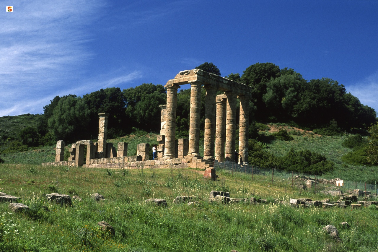
In 1954, L. Caboni, an ardent student at the Cagliari University, as part of her research for her degree thesis on Punic and Roman cults and temples in Sardinia, arrived in Antas and, in the accumulation of the blocks and architectural members of the temple, she discovered a fragment of the epistylium, which had hitherto escaped research, which, completed with a further inscribed block found in 1967, later allowed Giovanna Sotgiu to return the full lesson of the frontonal inscription.
At the beginning of the Sixties, another researcher, Foiso Fois, arrived in Antas, who was studying the Roman road network of the island. Fois made two observations of great interest: taking over the temple from scratch, on the one hand, he realized that the Cima had omitted two small quadrangular rooms in its plan that closed the chapel on the short north-western side, on the other hand, he understood that the building technique used to build the temple differed from that of the structures below the access steps. This last detail led Fois to hypothesize, six years before the beginning of the excavations, the Punic origin of the place of worship of Antas.
The temple seemed, however, destined to remain anonymous when, in 1966, during the preliminary work to organize the Antas area, in the accumulation of materials, a bronze table was recovered, bearing a dedication to Sardus Pater, promptly presented by Piero Meloni at the V International Congress of Greek and Latin Epigraphy in Oxford. The very important find was the first spy of the cult of Sardus practiced in the sanctuary of Antas. The following year, archaeological excavations returned a new fragment of the epistylium inscription, which was reassembled with the inscribed block discovered in 1954 giving the full title of the temple: Temp [l (um) D] ei FsA] di Patris Babfi] (Temple of the God Sardus Pater Babi).
The excavations took place in September 1967 and the following September 1968 and revealed, below the staircase of the Roman temple, a Carthaginian place of worship dedicated to the God Sid, to which about twenty Punic epigraphs referred. The excavation was followed in 1969 by a preliminary excavation report (“Punic Research at Antas”) published by the Institute for Near Eastern Studies of the University of Rome in the prestigious Semitic Studies series.
The volume contained an introduction by Sabatino Moscati, while Ferruccio Barreca oversaw the study of the temple. The rich epigraphic documentation was analyzed by Mohamed Fantar; Maria Giulia Amadasi was entrusted with the study of the God Sid; the Punic material categories (amulets, terracotta, coins) were published by Enrico Acquaro and Dalila Fantar; Serena Maria Cecchini, finally, gave the edition of the excavations of a late ancient village near the temple of Antas.
Update
Images
Audio


 Facebook
 Twitter
 LinkedIn
 Whatsapp

 Print
Print
 E-mail



Comments