The necropolis is excavated in a basaltic outcrop that dominates the Riu Mannu valley, along the Suni-Pozzomaggiore provincial road, in the Planargia region, in northwestern Sardinia.
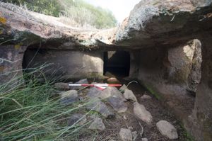
The hypogeic complex (chronologically framed in the final Neolithic period, 3200-2800 BC) includes 12 single-celled and multicellular burials, with access almost always consisting of a vestibule. The rooms, quite modest in size, often keep traces of red paint on the walls.
Tomb I consists of a small rectangular vestibule (width m 0.74; depth m 0.42; height m 0.76) on the back wall of which a semicircular cell opens (depth m 0.72; width m 0.90; height m 0.74), with a vaulted kiln.
Tomb II has a similar development in plan, consisting of a short quadrangular pavilion (width m 1; depth m 0.80/0.66; height m 0.84/0.90) which introduces - through a quadrangular entrance - into a square cell (depth m 1.26; width m 1.20; height m 0.85) with a slightly concave ceiling.
Tomb III is divided into two rooms: a quadrangular cell (depth m 1.70; width m 1.84/1.72; height m 0.86/0.94) with a sloping ceiling towards the entrance - preceded by a small open-air space - and a second quadrangular compartment (depth m 1.34; width m 1.34; width m 1.34; height m 0.90) accessible through a trapezoidal door.
Tombs IV and V have more complex floor plans.
Tomb IV, with a rectangular entrance door equipped with a framed recess (width m 0.44; height m 0.60; thickness m 0.20), consists of three rooms arranged on the transverse axis at the entrance. Cells A (depth m 0.82; width m 1.30; height m 0.66) and B (depth m 0.60; width m 1.26; thickness m 0.66) have a quadrangular plan, while cell C is semi-elliptical (depth m 0.92/0.80; width m 1.50; height m 0.52).
Tomb V - the largest and most complex in the necropolis - has a small pavilion that leads to a cell B, on whose left and back walls open two pairs of communicating cells.
Cell B, trapezoidal (width m 1.14/1.30; depth m 1.30; height m 0.92), preserves a circular dimple in the center of the floor (diameter m 0.18; depth m 0.07).
Tomb VI consists of a small semicircular cell (depth m 0.84; width m 1) with a kiln vault on which a small circular niche opens (depth m 0.50; width m 0.44; height m 0.46).
Tomb VII consists of a circular hallway A (depth m 1.08; width m 0.92/1.43), on the back wall of which the doors of two communicating cells open side by side.
Tomb VIII also has three cells, the first of which, with a recessed hatch, has a curvilinear plan (depth m 0.86; width m 1.08; height m 0.30) and a concave ceiling.
Tomb IX includes a short pavilion or antechamber, followed by two other connecting rooms on the same longitudinal axis.
Tomb X consists of a short pavilion A that leads into a quadrangular compartment B into which two cells (C and D) open. Cell C is characterized by its particular 'L' shape plan. In addition, in the back wall of the compartment, there is a small cabinet-niche (width 0.50 m; height 0.42 m) with a spherical cap.
Tomb XII is excavated in the highest sector of the outcrop. It can be reached with some difficulty from above and includes a quadrangular antecell (depth m 1.30; width m 1.40; height m 1.12/1.10), the main cell with a semi-elliptical shape (depth m 1.10; width m 0.60; height m 0.60/0.84) - with a slightly concave ceiling in the center and sloping towards the entrance - and another environment that is no longer detectable due to the collapse of the ceiling.
History of the excavations
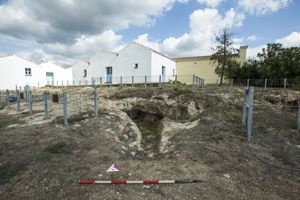
The necropolis has been known since the Taramelli was mentioned in the archaeological map.
Bibliography
A. Taramelli, "Foglio 205, Capo Mannu; Foglio 206, Macomer", in Edizione archeologica della carta d'Italia al 100.000, Firenze, Istituto geografico militare, 1935, p. 186, n. 5;
V. Santoni, "Nota preliminare sulla tipologia delle grotticelle artificiali funerarie in Sardegna", in Archivio storico sardo, XXX, 1976, figg. 5/40, 6/50;
A. Moravetti, "Beni archeologici", in Marghine-Planargia. Il piano di sviluppo socio-economico e il piano urbanistico comprensoriale della VIII Comunità Montana, 3, 6, 8, Cagliari, 1985, p. 50, fig. 1;
A. Moravetti, "La Planargia dalla preistoria all'età fenicio-punica", in La Planargia, Cagliari, Edisar, 1994, p. 94 ss., fig. 100;
A. Moravetti, Ricerche archeologiche nel Marghine-Planargia, II, collana "Sardegna archeologica. Studi e monumenti", 5, Sassari, Carlo Delfino, 1998, pp. 256-272.
How to get there
Exit from Suni and take the road to Padria. At km 63, after a double bend, there is, on the right, the trachytic outcrop in which the burials are dug. Leave the car and walk up the slope to the rocky front.
Structure category: archaeological area or park
Content type:
Archaeological complex
Archaeology
Usability: Open
Province: Oristano
Common: Suni
Macro Territorial Area: Central Sardinia
POSTAL CODE: 08010
Address: SS 292
Telephone: +39 0785 853009
E-mail: protocollo@pec.comune.suni.or.it
Website: comune.suni.or.it/luoghi/2974332/domus-de-janas-chirisconis
Information on tickets and access: To verify the actual usability of the archaeological site, opening hours and the cost of tickets, it is advisable to contact the town of Suni in advance.
Access mode: For a fee
Update
Services
![]() Guided tours
Guided tours
Where is it
Suni, Necropoli di Chirisconis Images number: 7

Comments