Subjects





The sanctuary is located on the southwestern edge of the “Giara” of Serri, a basalt plateau on the border between Trexenta and Sarcidano, in central-southern Sardinia.
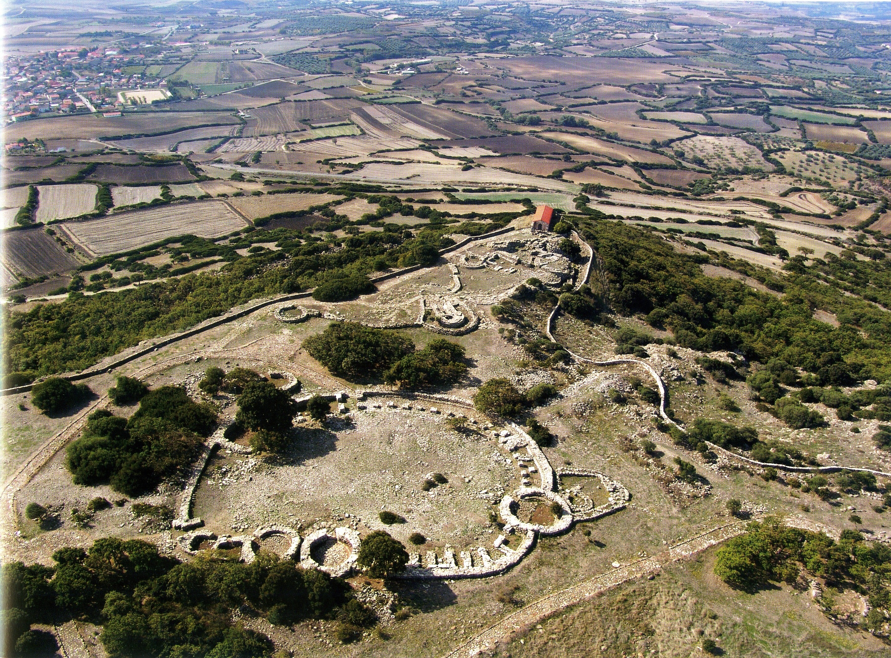
With its structures and extraordinary bronze ex-vots, Santa Vittoria is one of the most important cultural complexes in Nuragic Sardinia. Extending over more than 3 hectares, it is defended S/S-O by the natural cliff and N-O by a wall that follows the rocky edge.
The sanctuary, which underwent profound renovations over time, has four main groups of buildings: the two temples and the “priest's hut”, the “party enclosure”, the “double betyl” enclosure group and the E/S-E group, the last two perhaps linked to the permanent settlement. Aside from it are the “chief's hut” and other secluded rooms.
The first group, at S-O, is accessible through the entrance of a megalithic wall, originally marked by two betiles, which incorporates the “entrance” hut (diameter 6 m).
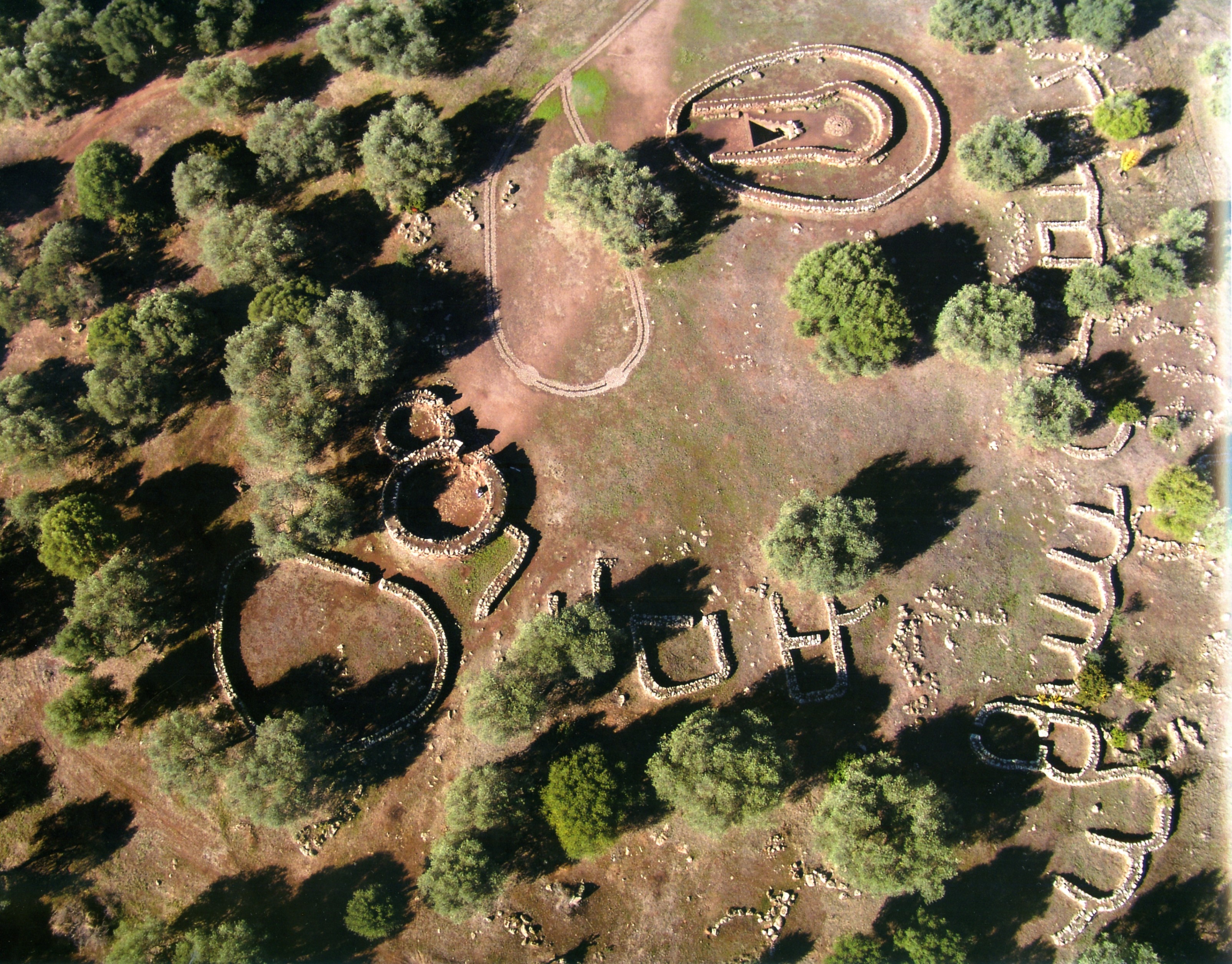
The sacred well, oriented N-E/S-O, is enclosed by an elliptical enclosure (19 x 13 m) and is made with very accurate rows of basalt blocks; it has the canonical pattern: atrium, staircase, well.
The atrium, square (m 2 x 2), has a paved floor, a count-seat and a rectangular altar with a cavity and drain hole for the flow of liquids.
The staircase, with 13 steps and a stepped roof, leads to the cylindrical well (diameter m 2), which originally had a “tholos” roof. The masonry consists of rows of perfectly worked basalt blocks (remaining height m 3 on 20 rows).
The front of the temple was perhaps originally decorated with a toothed frieze and two taurine limestone protomes.
A short distance away, at S-O, an open entrance in a curtain wall (length 14 m) leads to the “stone temple”. It was accessed through a “sacred road” (length m 50; width m 4/3), the same one that led with a curvilinear path to “hut 6” (diam. m 11.50), perhaps a room for meditation before entering the temple.
This rectangular (5.80 x 4.80 m), oriented N-S, with an S-shaped entrance, is built with regular rows of basalt blocks. It shows two sacrificial altars consisting of basalt counters and limestone slabs.
An S-shaped passage leads to the circular “priest's hut” (diam. m 8). It is preceded by a rectangular atrium (m 2.40 x m 2.80) with a seat and is built with square blocks of basalt and mortar.
Going up towards N along the defensive wall, you will find the remains of a pseudo-nuraghe (medium-recent bronze) on which the Romans supposedly erected a chapel to Victory.
At the N limit of the wall is the “cape's hut” (diameter m 5.50; remaining height m 4), with a trapezoidal atrium (m 5.50 x 5.30; height m 1.65) equipped with a paved floor and seats. The inner bedroom has 5 niches.
About 50 m in S-E is the “party enclosure”, with an elliptical plan (73 x 50 m; height 1.80 m), with entrances to S-O and S-E. The central area (50 x 40 m) overlooked large porches with niches and pillars, two quadrangular rooms with benches and seats, the “founders' enclosure” (diameter 6.70 m) with counter and niche, the “market” with 9 rectangular rooms (4 x 2 m) equipped with seats and plates for displaying goods.
Also included in the enclosure are: the “two-pen hut” (diameter m 6.95; height m 2), with the remains of the base of an altar and a decorated pillar; the “enclosure with circular seat” (diameter m 6.65); the “hearth house” (4.20 x 2.90 m); the “guardian's house” (2.50x2.90 m); a rectangular compartment (12 x 3 m) for the kitchen.
Among the buildings of the E/S-E group, the “enclosure of tortures”, circular and divided inside, and the “curia” or “hut of the federal assemblies”, circular (diam. m 14; interior m 11), with an entrance to S-E and a seat for about 50 people, stand out. On the walls, limestone plates, perhaps to support the offerings and niches, one containing a limestone tub. A trachyte basin was located to the left of the entrance. Sacred rites took place in the room.
The group of N-E shows a block of 6 huts open on common areas, including the “double betyl hut”, from the limestone artifact that was found there, which acts as an altar.
As far as dating is concerned, the sacred well dates back to the late Bronze Age - early Iron Age. Sector E and S-E, but not the 'curia', were abandoned by the 8th century BC. The rest of the sanctuary was in use and underwent renovations in the Punico-Roman era. Taramelli attributed the violent destruction and burning of the area to the Romans.
The church of Santa Maria della Vittoria and a cemetery were built on the site in Byzantine times. The church was rebuilt in the 11th-12th century.
History of excavations
The area was excavated several times by Antonio Taramelli between 1909 and 1929 and, in the 90s, by Maria Gabriella Puddu.
Bibliography
A. Taramelli, "Il tempio nuragico ed i monumenti primitivi di S. Vittoria di Serri (Cagliari)", in Monumenti Antichi dei Lincei, XXIII, 1914, coll. 313-436, figg. 1-119, tavv. I-VIII;
A. Taramelli., "Nuove ricerche nel santuario nuragico di Santa Vittoria di Serri", in Monumenti Antichi dei Lincei, XXXIV, 1931, coll. 5-122, figg. 1-67, tavv. I-III;
G. Lilliu, La civiltà dei Sardi: dal Neolitico all'età dei nuraghi, Torino, ERI Rai, 1980, p. 240 ss., figg. 43-47, p. 320, fig. 66;
G. Lilliu, "L'oltretomba e gli dei", in Nur: la misteriosa civiltà dei Sardi, a cura di D. Sanna, Milano, Cariplo, 1980, p. 110 ss., 116 ss., figg. 91-93, p. 134;
E. Contu, "L'architettura nuragica", in Ichnussa. La Sardegna dalle origini all'età classica, Milano, Scheiwiller, 1981, pp. 99, 103 ss., tav, VII, b-c, p. 105 ss., pp. 115, 117, 122, 128 ss., figg. 121-124, 126-128, 141;
G. Lilliu, "Serri. Loc. Santa Vittoria", in I Sardi: la Sardegna dal Paleolitico all'età romana, a cura di E. Anati, Milano, Jaca Book, 1984, pp. 230-233;
R. Zucca, Il santuario nuragico di S. Vittoria di Serri. Sassari, C. Delfino, 1988 (Sardegna archeologica. Guide e itinerari; 7);
M.G. Puddu, "Recenti sondaggi di scavo a Santa Vittoria di Serri", in La Sardegna nel Mediterraneo tra il Bronzo medio ed il Bronzo recente (XVI-XIII sec. a.C.). Atti del III Convegno di Studi "Un millennio di relazioni fra la Sardegna ed i paesi del Mediterraneo"(Selargius-Cagliari, 27-30 novembre 1986), Cagliari, Amministrazione provinciale-Assessorato alla Cultura, 1987, pp. 145-156.
How to get there
From the town of Serri, follow the indications on the location of the sanctuary on the tourist signs that lead to a paved road that, in about 4 km, leads to the archaeological area with parking and ticket office.
Structure category: archaeological area or park
Content type:
Archaeological complex
Archaeology
Usability: Open
Province: South Sardinia
Common: Serri
Macro Territorial Area: South Sardinia
POSTAL CODE: 09063
Address: strada comunale Santa Vittoria
Telephone: +39 329 7867983 +39 346 0669068 +39 3459991175
E-mail: prenotazioni@fondazionepetrass.it acropolinuragica@tiscali.it fondazionepetrass@pec.it coop.acropoli@legalmail.it
Website: www.fondazionepetrass.it/santa-vittoria www.acropolinuragica.it
Facebook: it-it.facebook.com/santavittoriaserri
Instagram: www.instagram.com/santavittoriaserri
Information on tickets and access: For up-to-date information on opening hours and ticket prices, we recommend visiting the operator's website. The ticket office closes approximately one hour before closing time.
Access mode: For a fee
Update
Services
 Teaching room
 Bookshop
 Guided tours
Where is it
Serri, Santuario di Santa Vittoria Images number: 6
Video

Author : Convegno internazionale Il culto Mediterraneo delle acque <2002>
Year : 2002
Author : Convegno internazionale Il culto Mediterraneo delle acque <2002>
Year : 2002
Results 2 of 47820
View All


 Facebook
 Twitter
 LinkedIn
 Whatsapp

 Print
Print
 E-mail
Comments