The Petroglyph Park includes the necropolis of Moseddu (or Museddu), located in the northern area of the park, the necropolis of Mattarigotza, which is located in the central area of the park, and the necropolis of Tennero, south of the previous one. Altogether, the park contains 37 domus de janas.
The Mosseddu necropolis, quite degraded, includes 18 hypogea with a single-celled and multicellular planimetric scheme.
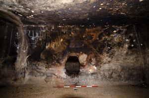
Among the hypogea, in the necropolis of Tennero, stands out the “White Tomb”, with an access “dromos” that leads, through a door equipped with a built-in door, into a rectangular cell.
The peculiarity of the hypogeum is given by the presence of petroglyphs, schematic figures engraved on the walls of the “dromos” and on the sides of the hatch near the entrance.
The petroglyphs - a total of twenty - are hammered, making grooves on average two and a half centimeters wide and about one centimeter deep.
Six anthropomorphic figures are represented on the wall of the 'dromos'. They have a threadlike body - some have raised forearms -, a head rendered from a simple disc and the male sex just mentioned. The arrangement of the figures suggests the idea of a dance, perhaps the 'round dance'.
On the wall d. there are eight figures, five of which are clearly male. Some of them raise their arms according to the prayer pattern and show an extension of their heads to beak: this last characteristic has led to the assumption of masked characters.
In some cases, due to their particular position, the figures seem to depict acrobats, in other cases the presence of weapons, such as axes, is noted.
A single figure stands out from the others: it is an 'upside down' that represents the deceased in the descent into the afterlife.
In some petroglyphs - although extremely stylized - female figures seem recognizable. The necropolis dates back to the final Neolithic (culture of Ozieri, 3200-2800 BC) and to the Eneolithic period.
History of the excavations
The necropolis has been marked since the middle of the last century.
Bibliography
A. Taramelli, "Foglio 193 (Bonorva)", in Edizione Archeologica della Carta d'Italia, Firenze, Istituto Geografico Militare, 1940, p. 86, n. 84;
E. Contu, "Moseddu (Cheremule), Notiziario", in Rivista di Scienze Preistoriche, XX, 1965, pp. 381-382;
G. Tanda, L'Arte delle domus de janas nelle immagini di Jngeborg Mangold, Sassari, Chiarella, 1985, p. 29, n. 15.
P. M. Derudas, "Il parco dei petroglifi. Uomo e paesaggio nella Valle di Cheremule" in Dalle domus de janas agli impianti di vinificazione, Cagliari, Regione Autonoma della Sardegna, 2013, pp 12-67.
How to get
from the town of Cheremule, leave the town via Vittorio Emanuele. After about one km, turn right at a watering hole and continue straight ahead, then turning at the second fork on the left. Continue to a watering hole and continue straight on the dirt road until you reach a concrete bridge over a canal. From this point you can see a rocky outcrop of limestone to the northwest, to which you have to go on foot, to the point where the electric poles meet the rock. From here, continue for about 150 m along a small road that runs along the outcrop and leads to Mount Cuccureddu. The White Tomb is visible on the rock wall on the left a couple of meters high. Continuing for another 100 m is the Tomba della Cava, located in a swampy meadow.
Structure category: archaeological area or park
Content type:
Archaeological complex
Archaeology
Usability: unmanaged site
Province: Sassari
Common: Cheremule
Macro Territorial Area: Nord Sardegna
POSTAL CODE: 07040
Address: SP 30 - località Badde Elzanas
Update
Where is it
Cheremule, Petroglyph Park Images number: 4
Video

Year : 1994
Results 2 of 47966
View All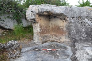
Comments