The archaeological complex called "Nuraxi Fenu" is located in a locality of the same name north-east of the town of Pabillonis, adjacent to the railway line that leads to Golfo Aranci, within a fertile, rich plain affected over the centuries by intense agricultural activities .
The archaeological complex extends over an area of approximately 1,600 square metres: its position is along the ancient road axis which, from the Marceddì lagoon, led inland passing through the Sardara spa, the Aquae Neapolitanae di Età Roman.
The western portion of the archaeological area had been partly dismantled around 1870 for the construction of a bridge to support the railway but the entire area, affected by centuries-old and intense agricultural activity, appears to have suffered damage.
The site was the subject of repeated excavation campaigns in the period 1996-2004 which brought to light the structures throughout its entire extension.
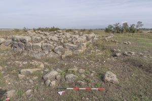
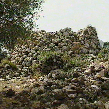
The central part of the complex is occupied by a polylobed nuraghe built with basalt blocks, of which five towers are recognisable, in addition to the main one around which they develop, including an internal courtyard.
On the northern side the building is protected by a turreted wall, in which a village of huts is inserted between it and the central bastion, while other huts develop in the southern sector. The sections of land that delimit the archaeological excavation give a glimpse of how the structures continue beyond the excavated and fenced area. The nuraghe, with a complex plan, was built in its main structural parts with polyhedral basalt blocks of cyclopean dimensions. It consists of a central tower which is little preserved in height and overlooks a semi-circular courtyard on the north-east side: around this main body there are three other circular towers, clearly recognizable despite the obvious additions and modifications carried out in different periods. To the south-east we find tower A, symmetrical to tower C, with which it shares a similar diameter and wall texture.
To the north-east we find tower B, the one with the largest diameter, built with a powerful external wall facing, however occupied inside by a large quantity of collapsed material inside which numerous finds were found: two boat lamps, fragments of pans, keeled terracotta bowls, pestles, spindles. Starting from the North-West, the tower called C is highlighted in elevation and plan, inside which, under the layer of burn caused by a vast fire that affected the entire area in ancient times, fragments of ceramic containers were found of various shapes and sizes. The three towers are connected to each other by short, slightly curved sections of walls, within which it is not possible to highlight whether there were communication corridors between the various rooms. The western sector, overlooking the railway bed of the Cagliari-Golfo Aranci line, is the one that has undergone the greatest removal of construction material, but not enough to preclude the completion of the planimetric reading of the monument: on the mistral side it is in fact visible a stretch of masonry technically attributable to the same workforce that built the other structures, so the presence of a fourth tower, called F and finally, to defend the south-west slope, of a fifth tower, called G, the least visible, is conceivable. A further external defensive body was added to the polylobed bastion, following the typology of the turreted antemural, of which on the northern side two towers connected by a straight section of masonry, called D and E, are certainly recognisable, while the presence of a third, always in this sector. The tower called D has revealed phases of the Recent Bronze Age (of note are six large terracotta andirons, three bowls, a pan).
Some structures of the monumental complex show clear signs of modifications to the original buildings, both inside the turreted bastion and outside: in particular, both in the northern sector, between the antemural and the nuraghe, both in the southern sector and in the tower called A highlights the traces of circular walls built with medium-small sized basalt stones not pertaining to defensive constructions, but more likely residential ones. The presence of stone material on the ground, although not in large concentrations, appears to be quite widespread, so it cannot be ruled out that the village could extend far beyond the area best visible today, the one excavated in years recent. The archaeological investigation made it possible to detect the phases of life of the village: the most documentable one is dated to the end of the Final Bronze Age (before the 9th century BC), with attendance in the Punic Age and up to the late Roman Imperial Age, when the original structures, albeit with renovations, adaptations and additions, were used more or less sporadically (Punic commercial amphorae, sealed A and common ceramics have been found in the area).
The site as a whole has undergone several phases of abandonment and more or less partial reoccupation. From the analysis of the excavation data it is possible to hypothesize different moments of life of the area ranging from the Middle and Recent Bronze Age (period in which local people settled in that plain attracted by the fertility of the soil and the presence of watercourses), with a maximum planimetric development in the Final Bronze Age (1150-900 BC), a phase of abandonment at the end of the Nuragic Age (determined by a violent fire), a sporadic re-frequenting of the area in the Punic Age and then stable re-occupation in the Roman Age.
History of excavations and studies
The site was affected by several stratigraphic excavation campaigns conducted in the period 1996-2004 which brought to light a complex nuraghe consisting of a probably five-lobed bastion placed to protect a central keep, surrounded by a wall that enclosed the village huts, highlighting different phases of attendance from the Recent Bronze Age to the Historic Age.
The archaeological complex, however, has been well known and renowned for its majesty since the nineteenth century: in fact, Vittorio Angius defines the Nuraghe Fenu as "worthy of being considered and counted among the greatest known", but on 18 March 1880 the parish priest of Pabillonis G. Puxeddu, in a hand-filled form, writes: "Nuraghe Nuraxi de Fenu. State of conservation in which it is found: destroyed" In 1918 A. Taramelli confirmed and clarified the news by stating that "in the Campidano section of Pabillonis [... .] there was the beautiful Fenu nuraghe, dismantled for the construction of a railway bridge" and places it among the prehistoric monuments located in the "Rivus Sacer basin", the current Rio Sitzerri, in the territory between Neapolis and Sardara, while in 1998 G. Ugas lists the Fenu nuraghe together with the Santu Sciori nuraghe as the only complex nuraghes still existing in the municipal territory of Pabilllonis.
Bibliography
Superintendence for Archaeological Heritage for the provinces of Cagliari and Oristano, Nuragic Complex of Nuraxi Fenu. Report, for the purposes referred to in Decree no. 10 of 15 January 2015. Report from the Superintendency of Archaeological Heritage of Cagliari-Oristano; MIBACT decree n. 10.2015.
F. Fanari (ed.), Report on the archival and bibliographic sources relating to the archaeological heritage of the Pabillonis territory, Municipality of Pabillonis, Department of Archaeological Resources, Pabillonis 2016. www.comune.pabillonis.su.it/images/BENI_ARCHEOLOGICI/ REPORT.pdf.
L. Usai, Nuraghe Fenu. Recent discoveries, III Culture Week "Italy a culture to live", photographic exhibition 9-31 March 2001 (Current archive of the Superintendence for Archaeological Heritage for the provinces of Cagliari and Oristano, Faldone 3.1. Pabillonis).
G. Ugas, Centrality and periphery. Models of land use in the Nuragic age: the Guspinese, in M. Khanoussi, P. Ruggeri, C. Vismara C., Roman Africa. Proceedings of the XII study conference. Olbia, 12-15 December 1996, vol. II, pp. 513-548. eprints.uniss.it/6110/1/Khanoussi_M_Africa_romana_2.pdf.
R. Zucca, Neapolis and its territory, Oristano 1987, p. 135.
L. Congiu, Archaeological catalog essay. Sheet 225 iv, NE-SE of the Map of Italy, Degree thesis academic year 1946-47, supervisor prof. Giovanni Lilliu.
A. Taramelli, The nuragic temple of S. Anastasia of Sardara (province of Cagliari), part one, chapter 1. The river sacer basin and its prehistoric monuments, in Ancient Monuments of the Lincei XXV, 1918, 5-25 figs. 1-2, www.bdl.servizirl.it/bdl/bookreader.
G. Puxeddu, List of monumental buildings, ruins and artefacts of historical and archaeological importance existing in the territory of the Municipality of Pabillonis Province of Cagliari, 1880 March 18, in the Ministry of Public Education, List of monumental buildings in Italy, (Folder: List Works of Monumental Interest 1880/1884), Rome 1902, p. 491.
V. Angius, sv. Pabillonis, in G. Casalis, Geographical historical statistical commercial dictionary of the states of s. M. The King of Sardinia, XIV, 1846.
How to get
Nuraxi Fenu is located about 3 km from the town centre. Follow the SP4.3 road which from Pabillonis leads to Sardara. Once you have passed the railway gates, turn right into a small road parallel to the railway tracks.
Content type:
Archaeological complex
Archaeology
Usability: unmanaged site
Province: South Sardinia
Common: Pabillonis
Macro Territorial Area: South Sardinia
POSTAL CODE: 09030
Address: SP 4.3 - località Nuraghe Fenu
Update
Where is it
Pabillonis, Area archeologica Nuraghe Fenu Images number: 3
Images
Author : ambito nuragico

Author : ambito nuragico
Results 2 of 118721
View AllVideo

Comments