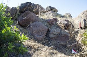
The necropolis is excavated in the tender trachyte of the S side of Punta Gannau; the fertile plains that cross the S border from the modest volcanic relief towards the suggestive natural coastal habitat of Santa Caterina e Cortiois and on the isthmus of Sant'Antioco, still marked - among the re-emerging traces of ancient villages - by the gigantic aniconic menhirs of Su Para and Sa Mongia.
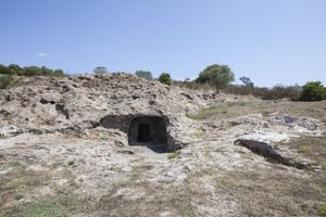
The necropolis includes 13 tombs, but it is very likely that the dense vegetation hides the entrances to other hypogeums. The domus are mainly multicellular, even if the number of rooms is not very large. The planimetric pattern, detectable only in part in some of them due to the poor state of conservation, is almost always a longitudinal projection, with an entrance pavilion (m 1.68 x 1.20 x 1 in height), anti-cell - sometimes semicircular in plan (m 2.05 x 2.85 x 1.60 in height) - and a large quadrangular room (m 2.48 x 2.38 x 1.50 in height). The tombs are divided into several kiln cells, in number from two to five, raised above the floor level; the entrances to these rooms sometimes have doors embellished with framed recesses.
The archaeological investigation of the entrance pavilion of Tomba IV has returned a very important stratigraphic sequence that allows us to evaluate the wide chronological-cultural arc of the necropolis, between the first centuries of the third millennium and the first centuries of the following. Ozieri, Filigosa, Abealzu, Monte Claro, Vaso Campaniforme and Bonnanaro culture materials come from this necropolis.
From an unspecified hypogeum of Locci Santus, there is also an idolet in trachitic tuff (27.5 cm high) with an ovival shape and a flat convex section. The head, expressed at the front in a roughly rhomboidal shape, has no physiognomic elements. At the waist it shows a series of inscribed squares; the sides - flattened - have a slight vertical groove. On the back it shows a wide horizontal band bounded by parallel incisions. A triangle in the nape area could be the stylization of a headpiece. The ogiva figurative pattern reproduces in miniature that of the menhir statues of Sarcidano and Barbagia by Belvì and Marghine.
History of excavations
An emergency excavation was carried out in the early sixties of the last century by Enrico Atzeni.
Bibliography
G. Lilliu, The civilization of the Sardis from the Paleolithic to the Age of the Nuraghi, Turin, Nuova ERI, 1988, pp. 161, 276, 432;
E. Atzeni, “The “culture of the bell-shaped vessel” in the necropolis of Locci-Santus (San Giovanni Suergiu)”, in Carbonia and Sulcis: archeology and territory, Oristano, S'Alvure, 1995, pp. 119-143; G. Lilliu, “Prehistory and protohistory of Sulcis”, in Carbonia and Sulcis: archeology and territory, Oristano, S'Alvure, 1995, pp. 119-143; G. Lilliu, “Prehistory and protohistory of Sulcis territory”, in Carbonia and Sulcis: archeology and territory, Oristano, S'Alvure, 1995, pp. 119-143;
G. Lilliu, “Prehistory and protohistory of Sulcis territory”, in Carbonia and Sulcis: archeology and territory, Oristano, S'Alvure, 1995, pp. 119-143;, edited by V. Santoni, Oristano, S'Alvure, 1995, pp. 13-50.
How to get
from San Giovanni Suergiu, exit for Carbonia on the SS 126. At km 11, turn towards the town of Is Puxeddus, then towards Is Urigus. On this road, after traveling 1 km, you come to an intersection where you turn left; continue for about 1.6 km, coming near a high voltage pylon on the right of the road. From this point, the road begins that goes up to the top of the hill, on which you can see a fort to the right of which there is a nuraghe and the Domus de Janas. The last stretch of road is accessible only on foot.
Content type:
Archaeological complex
Archaeology
Usability: unmanaged site
Province: South Sardinia
Common: San Giovanni Suergiu
Macro Territorial Area: South Sardinia
POSTAL CODE: 09010
Address: località Is Loccis Santus
Update
Where is it
San Giovanni Suergiu, Necropoli di Locci Santus Images number: 1
Images
Video


Comments