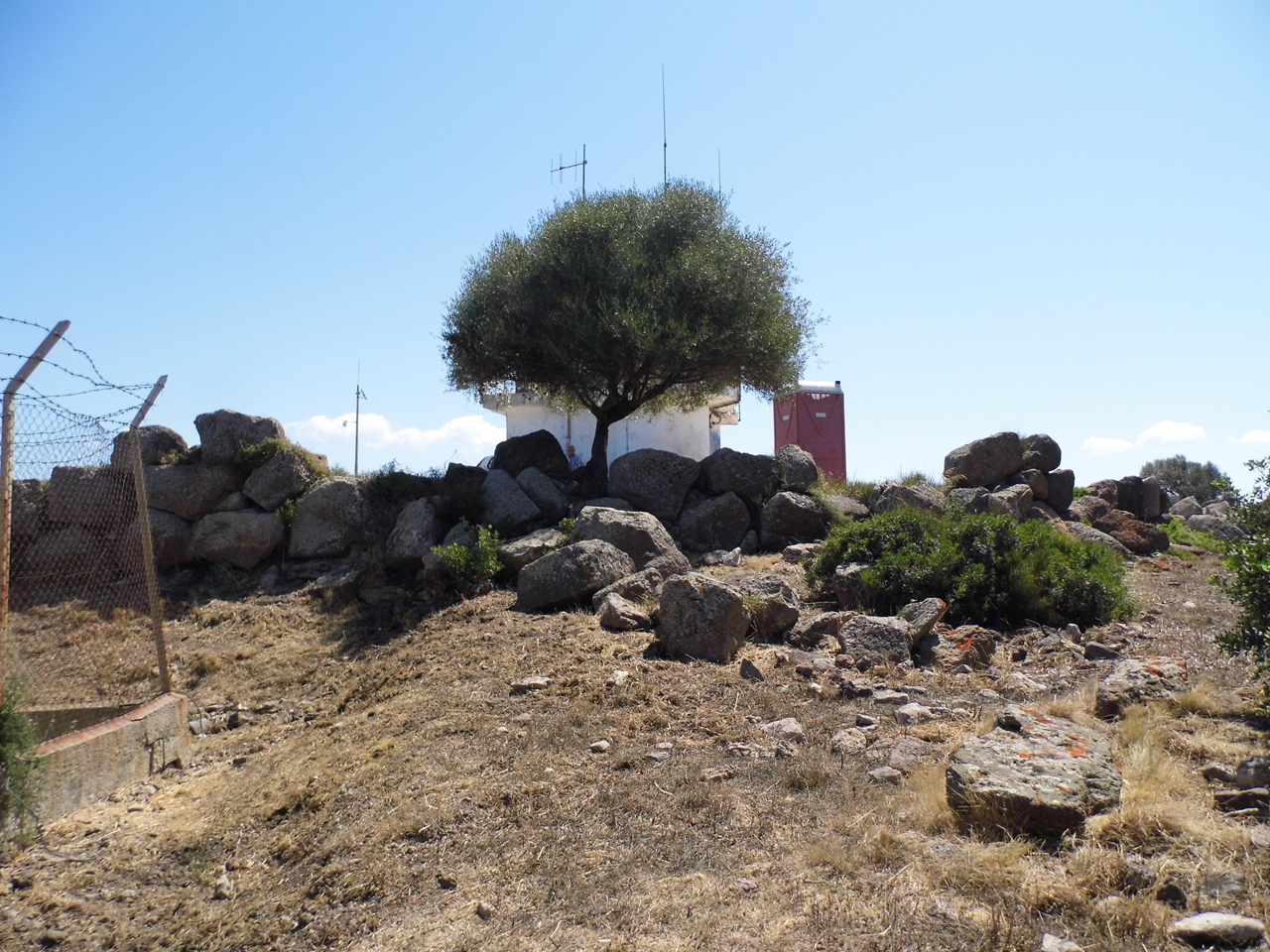
The archaeological site is located on the top of a trunk-pyramidal trachytic relief (m 348 m above sea level) with a wide visual domain over the valley below, on the mouth of the Coghinas and on a good stretch of coast to the E of Castelsardo.
The complex includes a small high-altitude village defended by a megalithic wall, according to a settlement typology well documented during the Eneolithic period.
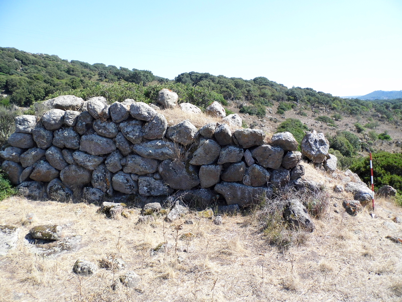
The wall (length about 60 m) delimits the eastern area of the plateau (1,636 square meters, 60 in surface), protecting the only side not protected by sheer walls.
The curtain (height max. 3.45 m in three rows), which develops curvilinear and orientation from NE to SE, is made with large trachyte blocks that have just been drafted, installed on almost regular horizontal rows.
At present, it is difficult to identify the entrance to the wall due to the collapse of most of the structures; however, it is likely that the access opened, in an easily defensible position, at the southern end, at a distance of just 6 m from the cliff.
The village extends both inside the area delimited and defended by the wall and outside along the steep edge of the hill.
The residential structures located inside, once identifiable among the dense shrub vegetation, have not been excavated and have unfortunately been destroyed by the construction of a fire service building; even outside, mechanical vehicles have partly disrupted and devastated the remains of the town.
The excavations conducted by Moravetti have returned ceramic material mainly from Monte Claro culture and the Campaniform Vase (evolved and final Eneolithic). The discovery of Bonnannaro cultural and historical materials attests to a prolonged visit to the area.
History of excavations
The site was the subject of an emergency excavation (conducted in 1979 by Alberto Moravetti) following the damage caused to the structures by the work to install a RAI repeater. The brief intervention was limited to some essays carried out close to the inner wall of the wall.
Bibliography
A. Moravetti, “Sardinia Newsletter”, in Journal of Prehistoric Sciences, XXXIV, 1979, pp. 332-334;
P. Melis, La domus dell'Elefante, series “Archaeological Sardinia. Guides and Itineraries”, Sassari, Carlo Delfino, 1991, pp. 38-39;
A. Moravetti, “Megalithic walls and fences in prenuragic Sardinia”, in M.S. Balmuth-R.H. Tykot, Sardinian and Aegean chronology: towards the resolution of relative and absolute dating in the Mediterranean, series “Studies in Sardinian archaeology”, Oxford, Oxbow, 1998, pp. 161-178;
A. Moravetti, “On the megalithic fortifications of prehistoric Sardinia”, in Aspects of Prehistoric Megalitism, Dolianova, Grafica del Parteolla, 2001, pp. 22-30.
How to get
From Castelsardo, take the SS 134 of Anglona to Perugas, to Multeddu; take the dirt road that goes up the hill of the “Rock of the Hunters” and proceed to the forest afforestation area for about km 2, at the E end of Mount Ossoni, where the fire service station is located.
Content type:
Archaeological monument
Archaeology
Usability: unmanaged site
Province: Sassari
Common: Castelsardo
Macro Territorial Area: Northern Sardinia
POSTAL CODE: 07031
Address: SS 134 - località Monte Ossoni
Update
Where is it
Texts
![Monte Ossoni (Castelsardo, Prov. di Sassari) : [scoperte e scavi preistorici in Sardegna negli anni 1978 e 1979]](data:image/png;base64,iVBORw0KGgoAAAANSUhEUgAAAAEAAAABCAQAAAC1HAwCAAAAC0lEQVR42mNkYAAAAAYAAjCB0C8AAAAASUVORK5CYII=)
Author : Moravetti, Alberto
Author : Moravetti, Alberto
Results 2 of 1478259
View AllVideo
Comments