Subjects





The nuraghe is located half the coast of the Crastu Littu slope, in a position of extensive domination over the Macomer plain and on the plateaus of Abbasanta and PauliLatino.
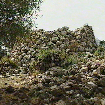
It is a complex nuraghe - one of the best preserved in the Marghine - which includes a main tower to which, on the front, a bastion with two towers has been added.
The two-lobed add-on body (m 17.50 x m 21; height 6.10/4.50 m) - built with large trachyte blocks arranged in regular rows - is accessible through a spared entrance in the center of the front curtain, slightly concave, on the same axis as that of the keep.
The quadrangular entrance (width 1.18 m; height 1.58 m) and closed by an architrave (length 2.35 m; width 1.05 m; thickness 0.65 m) with a drain window above it, leads into the entrance (length m 3.65; width m 1.18/2.15/1.70; height m 2.75) which has the two opposite entrances of the side towers.
The entrance to the tower is trapezoidal (width 1.20/0.45 m; height 2.20 m), leads to a corridor - with a flat scalar roof - which progressively widens into an elliptical environment (m 5.70x4.00) with a still intact “tholos” roof (height 5.40 m). In a position decentralized towards the corridor, there is a slightly raised slit on the floor level (length 2.15 m; width 0.55 m).
The tower is accessible through a rectangular corridor (length 2.25 m; width 1.50/1.70 m) that leads to a circular environment (diameter 4.55/4.10 m; residual height 4.50 m).
The access to the main tower consists of a large trapezoidal entrance oriented to SE (width m 1.70/1.10; height 1.25 m above sea level), closed by an architrave (length m 2.85; width m 1.10; thickness m 0.80) with an exhaust compartment.
The keep, circular in plan (diam. m 14.10/14.98; height 14 m), is built with trachyte blocks with decreasing dimensions upwards, worked with care and arranged in horizontal rows.
The rear door, trumped (length 5.10 m; width 1.70/2.30 m; height 2.65/2.70 m), has the entrance to the spiral staircase that leads to the upper floors (width 1.28 m; height 3.25 m).
An arched trapezoidal entrance (height 2.65 m) with an exhaust window leads into the circular chamber (m 5.10x4.90) with a “tholos” vault without the last rows (height 6.58 m). The floor plan of the room is marginalized by three niches arranged in a cross - with arched entrances and a projecting ceiling - and, at the base, by four cabinets.
Through the stairwell, you can access the first floor room illuminated by a quadrangular architraved window (length 1.55 m; width 0.70 m; thickness 0.45 m).
On the access road, on d., the trapezoidal entrance (width m 0.67/0.43; height 0.91 m) of a quadrangular niche (depth 1.50 m; width 0.50/0.70 m) opens, which has the mouth of a storage well (width m 0.67/1.62; depth m 3) in the floor plan.
The room, intact, rather crushed in plan (diam. m 4.60/3.30; height 5.90 m), is expanded by three niches and two storage wells with access at floor level.
In front of the entrance to the chamber, there is a slot (depth 1.75 m; width 0.35 m; height 0.40 m), while at the base of the wall d. of the compartment, a large opening (width 0.90/0.45 m) opens in the floor.
A second storage well opens into the entrance wall (diam. m 2.50; depth m 3).
The staircase continues to the top floor where you can identify the remains of a third room.
Around the monument, over a large area, there are the remains of numerous circular and rectangular huts and of an antewall that defends the settlement towards S, delimiting an area of 2,264 square meters.
History of excavations
The site has undergone excavation and restoration by the Superintendence for Archaeological Heritage of Sassari and Nuoro (1997).
Bibliography
V. Angius, in G. Casalis, Historical-Statistical-Commercial Geographical Dictionary of the States by H.M. the King of Sardinia, II, Turin, G. Maspero, 1834, p. 517;
A. Della Marmora, Voyage en Sardaigne ou description statistique, phisique et politique de cette ile avec des recherches sur ses productions naturelles et ses antiquités, II (antiquités), Paris, A. Bertrand-Torino, J. Bocca, 1840, p. 107; G. Spano, Memory above the cathedral by Ottana and archaeological discoveries made on the island throughout the year 1870, Cagliari, Typography of Commerce, 1870, p. 31;
A. Taramelli, “Sheet 205, Capo Mannu; Sheet 206, Macomer” in Archaeological Edition of the Map of Italy at 100,000, Florence, Military Geographic Institute, 1935, p. 58, n. 41; A. Moravetti, Preliminary Report on the archaeological monuments of the municipalities of Birori, Borore, Bortigali, Macomer and Sindia, Macomer, 1973;
A. Moravetti, Archaeological Research in the Marghine-Planargia. The Marghine - Monuments, Part One. Sassari, C. Delfino, 1998 (Archaeological Sardinia. Studies and monuments; 5);
A. Moravetti, Archaeological research in the Marghine-Planargia. The Planargia — Analysis and Monuments, Part Two. Sassari, C. Delfino, 2000 (Archaeological Sardinia. Studies and monuments; 5).
How to get there
Leave the SS 131 at 149.5 km and take the road to Mulargia. After passing the hamlet, after about 2 km, continue to the right in the direction of Bortigali; after 600 meters, on the right, there is an uphill asphalted road that leads to the shooting range. Follow it for another 600 m, until you reach a fork; take the road to the right and reach the nuraghe after 400 meters.
Content type:
Archaeological complex
Archaeology
Usability: unmanaged site
Province: Nuoro
Common: Bortigali
Macro Territorial Area: Central Sardinia
POSTAL CODE: 08012
Address: SP 62 - località Orolo
Update
Where is it
Bortigali, Nuraghe Orolo Images number: 5
Video


 Facebook
 Twitter
 LinkedIn
 Whatsapp

 Print
Print
 E-mail


Comments