Subjects





The nuraghe rises on the east-northeast edge of the town of Armungia, among the mountain reliefs of the Gerrei, in a dominant position over the Flumendosa valley. It is located a short distance from the “Sa Domu de is Ainas” Ethnographic Museum, which thus also constitutes the access structure for visiting the site.
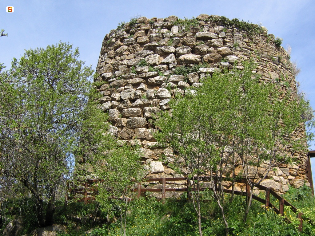
The building is a mono-tower with a diameter of about 13 meters at the base and a maximum residual height of 10.5 meters. The external wall work, of which 21 rows of limestone blocks are preserved, becomes more accurate as the wall rises upwards, with stones that decrease in proportion from the bottom to the top. The entrance wall to the monument, oriented to the south-east, shows an impressive restoration aimed at reintegrating the wall structures removed and reused in the nineteenth century in the construction of the old municipal building. The entrance leads into a corridor with an ogival section 4 meters long, trundled inwards (1.20 meters wide at the entrance, 1.60 meters at the bottom) and with an increasing height towards the room (2.80 meters at the entrance, 3.40 at the bottom). The entrance overlooks two triangular posts with curvilinear walls: the one on the right is 2.95 meters deep by 1.10 meters wide by 1.50 meters high, the one on the right is 2.50 by 0.95 by 1.42.
The corridor leads to the large tholos room, which has a diameter at the base of 5.40 meters and reaches a height of 8.25 meters, with a beautiful arrangement of 31 horizontal rows of mainly subsquared cut stones. The opening of the summit is due to the lack of the last rows that were originally supposed to close the false cupoliform vault. Along the wall of the compartment, there are two cells, positioned frontally along an axis perpendicular to the access corridor. The cell oriented to the northeast (1.40 meters deep by 1.90 in width by 2.95 in height) has a trapezoidal plan while the one to the southwest (1.45 by 1.90 by 2.75) has an elliptical plan and is characterized by the presence of an extension along the wall thickness. In 1985, in addition to the remains of ceramic artifacts from the Nuragic age, a bronze buckle dated to the 8th - 9th century AD was found in this cell. With the completion of the investigation, a Byzantine-era tank, plastered in crushed earthenware, probably reused over time also as a burial, re-emerged. The tank is thus a testimony to the reuse of the building in late ancient and early medieval times.
At 3.50 meters high from the floor of the room, in the stretch of wall between the corridor and the cell to the southwest, the entrance of the staircase created inside the wall that led to the terrace opens. The staircase (0.95 meters wide by 2.10 meters high), has 17 steps and is illuminated by a rectangular window in the initial section.
Some curvilinear wall sections from the Nuragic era, interpretable as reinforcing works, are visible in the outdoor area at the base of the building, on the north-east and south-west sides. The northeastern stretch in its current state rises above the country level by three rows of large polygonal blocks. In the absence of reference stratigraphic data, the nuraghe can be generically placed between the Middle and Recent Bronze Ages.
Unusual for its rise in the middle of the roofs of houses, incorporated into the urban fabric, the nuraghe testifies to the protohistoric origins of the center and preserves important traces of the continuity of the settlement over the centuries.
History of excavations
The monument was affected by renovations in the 80s and 90s of the twentieth century, by Emerenziana Usai and Maria Rosaria Manunza.
Bibliography
M. Pittau, La Sardegna nuragica, Sassari, Dessì, 1980;
G. Lilliu, I nuraghi. Torri preistoriche di Sardegna, prefazione di A. Moravetti. Nuoro, Ilisso, 2005, pp. 234-235.
How to get there
Starting from the SS 131 at the junction for Senorbì/Mandas, continue on the SS 128 to Senorbì and on the SS 547 in the direction of Villasalto. At the Sant'Andrea Frius exit, take the SS 387 to San Nicolò Gerrei and then the SP 27 to the junction with the SP 28. At the crossroads, turn towards Armungia. The nuraghe is in the center of the town, next to the old town hall.
Structure category: archaeological area or park
Content type:
Archaeological monument
Archaeology
Usability: Open
Province: South Sardinia
Common: Armungia
Macro Territorial Area: South Sardinia
POSTAL CODE: 09040
Address: piazza Municipio, s.n.c.
Telephone: +39 070 9589011 +39 070 5435109 +39 070 958123 +39 338 8994529
E-mail: sistemamuseale@comune.armungia.ca.it agora@agora.coop
Website: www.agora.coop/sistema-museale-di-armungia
Facebook: www.facebook.com/ArmungiaMusei
October - March
Wednesday - Thursday
10:00 AM - 1:00 PM
Friday
10:00 AM - 1:00 PM
Friday
3:00 PM - 7:00 PM
Saturday - Sunday
9:30 AM - 1:00 PM
Saturday - Sunday
3:00 PM - 7:00 PM
April - June
Wednesday
10:00 AM - 1:00 PM
Thursday - Friday
10:00 AM - 1:00 PM
Thursday - Friday
4:00 PM - 8:00 PM
Saturday - Sunday
9:30 AM - 1:00 PM
Saturday - Sunday
4:00 PM - 8:00 PM
July - September
Wednesday - Thursday - Friday - Saturday - Sunday
10:00 AM - 1:00 PM
Wednesday - Thursday - Friday - Saturday - Sunday
4:00 PM - 8:00 PM
Special openings: Special openings during the year: Easter Monday, April 25, May 1, August 15, December 8. Closed on December 25 and January 1.
Information on tickets and access: To check the usability of the site, opening hours and the cost of tickets, it is advisable to contact the site manager in advance before planning your visit.
Access mode: For a fee
Tickets :
Services information: Upon reservation, it is possible to request a guided tour service in French and English for the entire museum system. Reservation required for groups and schools.
Update
Services
 Guided tours
Where is it
Armungia, Nuraghe Armungia Images number: 3
Images
Video

Year : 2010
Author : Floris Laura
Results 2 of 48830
View All


 Facebook
 Twitter
 LinkedIn
 Whatsapp

 Print
Print
 E-mail
Comments