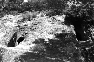
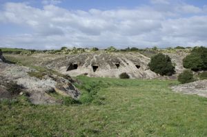
The burials are dug along the steep sides of a trachytic relief, near the south-eastern shore of Lake Omodeo, in Barigadu, a region of central Sardinia.
At the current time of research, the complex consists of 15 domus de janas.
The hypogeums, located at a considerable height on the country level (from a minimum of m 0.60 to a maximum of m 4.00) were originally accessible through pedaroles; the collapses and fractures of the rock wall make access particularly difficult today. In some cases, the domus can be reached, not without difficulty, by descending from the plateau above. The hypogeans generally have their entrance facing south/southwest. The planimetric scheme is mainly multicellular with a longitudinal development, sometimes enriched by lateral extensions to the right or left of the main axis. There are different cell plan profiles: rectilinear, curvilinear, recto-curvilinear. The walls and ceilings are generally in a straight profile and the corners are always rounded. The most interesting burial in the necropolis is undoubtedly Tomb X, called “Sa Cresia” (the church): it is a multicellular tomb with a large anticell with an irregular trapezoidal plan and a single sloping ceiling. On the back wall of the room, raised above the floor level, there are two access doors to the next rooms. Above the central door, a very valuable “false lintel” stands out - in relief from the wall. Many of these domus have traces of reuses and architectural reworkings after their first installation. Signs of these reuses are some quadrangular niches and sub-hemispherical cavities, dug into the walls of some hypogeans. In tombs IV, IX and X, niches, sometimes equipped with recesses, appear on the outer wall, near the entrances. In four cases - in tombs XI, XV, X and VIII - the niches open, instead, on the walls of the antecell. Sub-hemispherical cavities of uncertain function are present on the inner walls of tombs X and XV. In the case of Tomb VIII, originally composed of eight cells, the reuse caused the demolition of three rooms.
At the review age, perhaps due to the excessive reduction in the thickness of the rock, the ceilings of the adapted rooms subsided.
The necropolis, dating back to the final Neolithic - Eneolithic, was probably reused in Byzantine times.
Bibliography
M. Sanna, “Sorradile. Medieval reuses of the prehistoric necropolis of Santu Nigola”, in Sardegna Antica, 24, 2003, pp. 24-26.
How to get there
To reach the Prunittu necropolis from the town of Sorradile, you must exit in the direction of Bidonì and turn onto the municipal road that leads to the church of San Nicola. After about 1 km, after crossing the junction for the church of Santa Maria, continue for about 200 meters until you reach the sign that indicates the entrance to the archaeological area.
Content type:
Archaeological complex
Archaeology
Usability: unmanaged site
Province: Oristano
Common: Sorradile
Macro Territorial Area: Central Sardinia
POSTAL CODE: 09080
Address: strada comunale S. Nicola S. Maria - località Sorrana
Update
Where is it
Images
Video

Comments