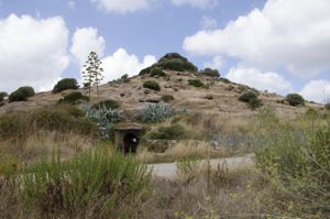
The necropolis of S'Adde 'e Asile is located in the territory of the Municipality of Ossi, within a vast forest area consisting mainly of oak trees, along the southern slopes of Mount Corona' and Teula. It is accessed from the ancient and suggestive stretch of Sas Rainanas, equipped with explanatory panels and directional signs.
The territory that falls within the municipal boundaries of Ossi is rich in areas of domus de janas and underground environments: in general, examples of single-celled structures are rare, while multicellular hypogeans with a complex planimetric pattern with a longitudinal projection are more widespread, the consequence of a first original nucleus with a simple pattern with a few spaces that has undergone expansions over time with variously articulated lateral additions.
This situation can also be identified in relation to the necropolis of S'Adde 'e Asile, characterized by hypogeans with a predominantly complex plan, in some cases attributable to subsequent expansions, while only one of the burials is single-celled.
To date, two groups of hypogeans called 'Great Tomb' and 'Tomb of the Sheep' have been identified and isolated outcrops that house the 'Tomb of the Hourglasses', the 'Tomb with a Coppella', the 'Tomb of the Windows', the 'Single Cell Tomb' and two others with the specimens under excavation.
The hypogeic necropolis consists, at the current state of knowledge, of 11 domus de janas excavated in low calcareous outcrops, mostly isolated and only partly grouped, distributed according to an apparently random logic (but probably influenced by the geomorphological conformation of the area) within a forest area of about one hectare. Two clear examples of excavation attempts have also been identified. This area houses some of the most significant Neolithic burials in all of Sardinia, both in relation to the planimetric scheme and in view of the architectural decorations found and not always present in the Domus de Janas complexes.
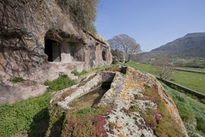
The so-called “Great Tomb”, for example, is a hypogeum with a longitudinal projection consisting of 21 rooms, not attributable to a unitary and original conception, but excavated at different times: in fact, four nuclei can be distinguished. It is located inside a limestone counter above the rock wall in which the so-called 'Tomb of the Sheep' was built.
The Great Tomb has triple-corniform decorations (consisting of three paved horns joined together by a short vertical strip), architectural pillars and frames, false doors, a double-sloped ceiling reproducing the roof of the houses, protomes with moonlike horns.
Of particular importance for its uniqueness in architectural decoration is the CD. “Tomb of the Hourglasses”: it looks like a multicellular hypogeum, oriented SSE, the result of several expansion interventions, dug into a low limestone counter; the domus takes its name from the repetition of geometric patterns made in the walls of the antechamber.
The CD. “Tomba dell'Ovile” was built by excavating a large limestone counter located a short distance from the Great Tomb. The access and the western portion of the structure were damaged by the demolition carried out to reuse the hypogeum as a shelter for animals: these interventions have disfigured the entrance façade and the floor plan, since the floor plans were lowered to make the structure more functional to provide shelter for livestock.
History of excavations
The necropolis, known in scientific literature as S'Adde 'e Asile or Brunuzzu, was identified for the first time by Ercole Contu in 1969 and, since then, scholars have detected its visible emergencies by giving brief communications, with particular reference to the Great Tomb.
An extensive archaeological survey of the area, however, was carried out only in 1984, thanks to a collaboration between the Archaeological Superintendence of Sassari and the Institute of Antiquities and Art of the University of Sassari, (dir. A. Moravetti): the excavations involved the 'Tomb of the Hourglasses', the 'Tomb with a Coppella' and the 'Clover Tomb'.
Subsequently, in 1994, the “Project for the Safeguarding and Valorization of the Cultural Heritage of the Territory of Ossi” was launched, through which, over the years, the systematic recognition of the context, the cataloguing and the planimetric survey of all the hypogeans and to make the site usable.
Bibliography
P.M. Derudas, The Necropolis of Mesu'e Montes (Ossi) and The Hypogeic Necropolises of S'Adde 'e Asile and Noeddale (Ossi), series “Archaeological Sardinia. Guides and Itineraries”, Carlo Delfino Editore, Sassari 2004.
P.M. Derudas (curated by), Ossi Places of Archaeology, Catalogue of the permanent photographic exhibition on the cultural heritage of the territory of Ossi, Ozieri 1998.
P.M. Derudas, The Necropolis of S'Adde 'e Asile - Ossi, Ozieri 1998.
P.M. Derudas, Ossi. Archaeology of the territory, Notiziario-Sardegna, in “Bulletin of Archaeology”, 43-45, 1995 (2004), pp. 148-152
G. Tanda, The Art of the Domus de Janas, Sassari 1985.
G. M. Demartis, Ossi (Sassari) Loc. S'Adde 'e Asile The Tomb of the Windows, in AA. VV., The Sardinians. Sardinia from the Paleolithic to the Roman Age, Milan 1984, pp. 285-287.
G. M. Demartis, Ossi (Sassari) Loc. It's Adde and Asile. The Great Tomb, in AA. VV., The Sardinians. Sardinia from the Paleolithic to the Roman Age, Milan 1984, pp. 285-287.
G. M. Demartis, The Tomb of the Windows by S'Adde 'e Asile (Ossi-Sassari), in “Proceedings of the XXII Scientific Meeting of the Italian Institute of Prehistory and Protohistory (Central-Eastern Sardinia)”, Sassari October 21-28, 1978, 1980, pp. 161-180.
E. Contu, S'Adde 'e Asile, Mesu 'e Montes (Ossi), Notiziario-Sardegna, in “Journal of Prehistoric Sciences” XXIV, 2, 1969, p. 379.
G. Chelo, Artificial Funeral Grotticels in the Sassari area, in “Sardinian Studies”, XII-XIII, Cagliari 1952-54, pp.82-89.
E. Contu, S'Adde and Asile (Ossi). Notiziario-Sardegna, in “Journal of Prehistoric Sciences” XXIX, 1, p. 265.
How to get
From Ossi, take the provincial road No. 97, at Km 5 turn left and continue until you reach a crossroads, then take the road that goes up to the right and continues for a few kilometers until you reach the Piogosa fountain (watering hole). From here, take the road to the left of the watering hole, walk about 300 meters and then turn left on a fairly narrow dirt road, after about 400 meters you arrive in front of the entrance to a private property where you can leave your car. The access to the path that leads to the archaeological site is on the left compared to the private entrance.
Structure category: archaeological area or park
Content type:
Archaeological complex
Usability: unmanaged site
Province: Sassari
Common: Ossi
Macro Territorial Area: Northern Sardinia
POSTAL CODE: 07045
Address: SP 97 bis - località Nuraghe Bainzo Olia, km 5
Information on tickets and access: The site is currently unmanaged.
Services information: There are no services.
Update
Where is it
Video
Audio


Comments