The settlement is located a few kilometers from the coast. Its strategic position is therefore given by its inclusion at the important junction of the Via Sulcitana represented by the area of Monte Sirai.
The first traces of life extend from the Neolithic to the Nuragic Age.
As an urban center, perhaps founded by the Phoenicians of Sulky or Portoscuso, Monte Sirai was already permanently inhabited around 730 BC. The subcoastal settlement is located in a region rich in mineral resources and in direct contact with numerous Nuragic settlements.
The Phoenician period (VIII-VI century BC) is documented in both housing and funerary settings.
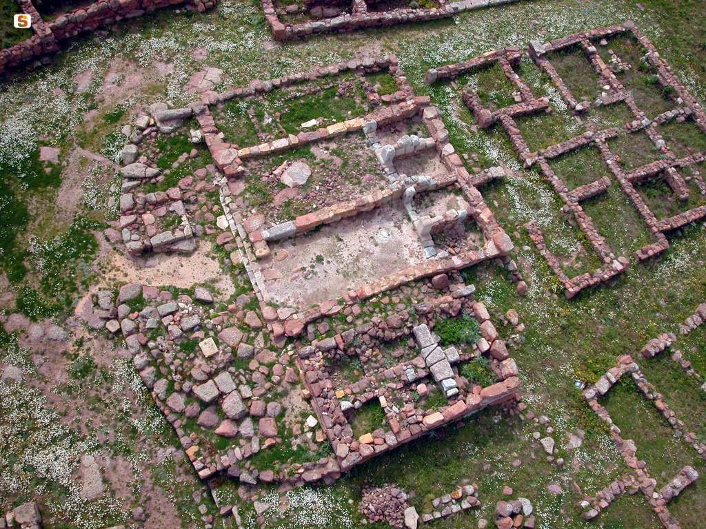
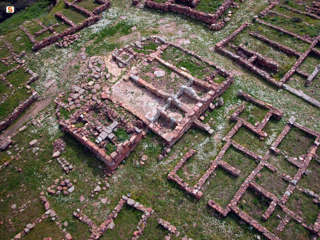
Some houses have been investigated on the acropolis, including the “Talco skylight house”, which give the image of a thriving center that was consolidated between the 7th and 6th centuries BC, when the urban fabric reached considerable dimensions.
The houses, built on four blocks arranged lengthwise, consisted of rooms articulated around a central courtyard, the true hub of all domestic activities. The presence of raised floors, plastered walls and channels for the flow of water highlight the skill of construction techniques.
A sanctuary with a two-part cell dedicated to the goddess Astarte (whose cult statue is preserved in the National Archaeological Museum of Cagliari) was built by reusing in part some previous structures of a single-tower nuraghe.
In the area of the necropolis, some of the numerous cremated burials and some burials refer to children and women. This fact, as well as the total absence of weapons among the elements that accompany male burials, seem to indicate that the settlement was designed mainly for civil use.
This is contrary to the military function and fortified center, proposed in the past for Monte Sirai, which has now been definitively traced back to a brief parenthesis in the entire history of the settlement. In fact, the walls of Monte Sirai were erected around the first years of the 4th century BC (375 BC) and lasted in operation until the dismantling following the Roman conquest of 238 BC. The historical events that marked the phase of transition to Punic domination have left tangible traces in terms of archaeological stratification. In fact, at the end of the 6th century BC, grave types changed radically with the introduction of burial in underground tombs with short “dromos” access.
In the housing sector, there were significant traces of destruction in living standards in the second half of the 6th century BC, attributable to the Carthaginian offensive. During the first years of the 5th century BC, therefore, there was a phase of economic recession that resulted in a sharp downsizing of the housing fabric, which entailed the total abandonment of areas previously used also for housing purposes.
Later, during the 4th century BC, there was a substantial recovery with the preparation of the fortifications and the installation of the “tofet”, while during the first half of the third century BC, the significant urban development involved the revitalization of areas that had previously been defunctionalized.
The definitive abandonment of the plateau occurred towards the end of the 2nd century BC (110 BC), probably due to the repression of banditry activity by the Roman armies. This seems to suggest the total absence of small objects in the last levels of life of the town where only large artifacts exist, a clear symptom of a sudden abandonment. The last traces of a sporadic visit to the plateau consist of a 4th-century AD coin found in the area of the Tofet and a ceramic find from the 7th century AD from the temple tank on the acropolis.
History of excavations
The investigations, started in 1999 as part of the CNR Monte Sirai Excavation Mission (later UniSS) - Ca-Or Archaeological Superintendence, have been conducted since 2008 by the Municipality of Carbonia - Villa Sulcis Archaeological Museum (scientific direction C. Perra) under the MiC Excavation Grant.
Bibliography
P. Bernardini, “The Origins of Sulcis and Monte Sirai”, in Studies in Egyptology and Punic Antiquities, 4, 1989, pp. 45-66;
P. Bartoloni, “Monte Sirai: genesis of a settlement”, in Meeting “The Phoenicians”, Cagliari, Autonomous Region of Sardinia, 1990, pp. 31-36; P. Bartoloni-S.F. Bondì-L.A. Marras, Monte Sirai, series “Itineraries”, Rome, Polygraphic Institute and State Mint, 1992;
P. Bartoloni, “The urban structure of Monte Sirai in the Republican Age”, in Proceedings of the X Study Conference “Roman Africa” (Oristano, 11-13 December 1992), Sassari, Gallizzi, 1994, pp. 817-829;
P. Bartoloni, The Necropolis of Monte Sirai, Rome, Institute for Phoenician and Punic Civilization, 2000; Monte Sirai. The works and the days, curated by P. Bernardini, C. Perra, Carbonia, 2001;
P. Bartoloni, “Monte Sirai 1999-2000. New investigations in the insular B”, in Journal of Phoenician Studies, 30, 2002, pp. 41-46;
P. Bartoloni, Monte Sirai. Sassari, C. Delfino, 2004 (Archaeological Sardinia. Guides and itineraries; 10).
How to get
From Cagliari: from the SS 130, at km 44, turn right up to Carbonia (SP2). Once in Villamassargia, turn right at km 57 for the SS126 state road (direction Sant'Antioco); at km 17, turn right and follow the signs.
Content type:
Archaeological complex
Archaeology
Province: South Sardinia
Common: Carbonia
Macro Territorial Area: South Sardinia
POSTAL CODE: 09013
Address: SS 126, km. 17 - località Sirai
Website: www.carboniamusei.it
Facebook: www.facebook.com/carboniamusei
Information on tickets and access: To visit the archaeological area, refer to the management of the Carbonia SimUC museum system: website.
Update
Where is it
Images
Video
Audio


Comments