The archaeological area is located at the extreme southern reaches of the Crastu Littu plateau, in a position of wide domination over the underlying plains of Abbasanta and Paulilatina, in the Marghine, a region of central-northern Sardinia.
The complex includes a corridor nuraghe, a building probably shaped like “tholos” and a small village of huts, located inside a wall; a dolmen is located a short distance away.
The corridor nuraghe - located on the western edge of the altitude, followed by the difference in altitude - is built with boulders just sketched and arranged on irregular rows with the help of numerous rising wedges.
The tower, elliptical (diam. m 9.62/8.54; height 4.90/3.85 m), has two entrances oriented to NE and SO, built at different levels. The NE entrance, trapezoidal and architraved (width 1.18 m; height 1.60 m), is now partly obstructed by the collapse of the huts that extend almost to the building; it leads to a curvilinear corridor (length m 8.65; width m 1.00-1.30-1.05; height 1.22-2.30 m) that crosses the entire building, opening outside through a trapezoidal entrance (width m 0.80; height m 1.20) with thin lintels equipped with an exhaust window. The corridor roof consists of flat slabs with a scalar profile, while the floor has some steps perhaps made to correct the inclination of the slope on which the monument stands. In the wall d. of the compartment, the arched entrance to a large elliptical niche opens (depth 2.08 m; width 0.90/1.16 m; height 1.85 m). A circular tower (diam. m 11.30-11.15; height 3.30 m) rises in the SE direction, about ten meters away from the protonuraghe and at a higher altitude. It is currently only possible to detect the floor plan and the elevated profile of the building.
The tower, unlike what is documented in the nearby protonuraghe, is built with large blocks just sketched and arranged in mostly regular rows. On the roof it is possible to identify the remains of some rooms that are now unusable.
The town that extended between the two towers preserves the circular profile of at least four huts (dimensions on average m 3.50 x m 2.90).
The two nuraghes and the village are protected by an antewall that follows the irregular edge of the hill, incorporating numerous rock highlights. The curtain wall is built, at the base, with large unprocessed blocks and in the upper rows with small stones.
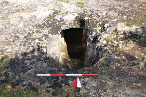
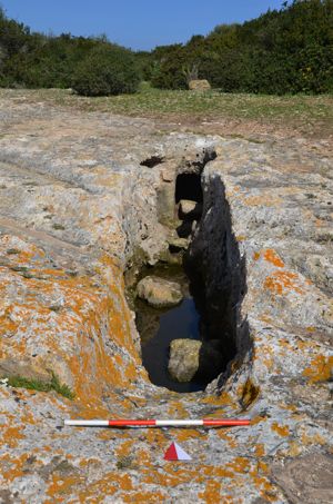
The excavation has also unearthed a unique well, probably with a cult function.
The complex dates back to between the ancient Bronze and the Final Bronze.
The dolmenic burial is located a few tens of meters to the N of the complex. It uses the shape of some rock outcrops and has a rectangular burial compartment (length 1.72 m; width 0.80 m; height 0.40 m) delimited, on three sides, by natural rock and five orthostats. The roof consists of a single trapezoidal slab (m 2.10 x m 1.52; thickness m 0.32/0.14) placed on the rock plane with the aid of wedges that regulate the installation plane.
History of excavations
The excavations of the area are in progress, by Alba Foschi.
Bibliography
A.Taramelli, “Sheets 205-206: Capo Mannu-Macomer”, in Edition of the Archaeological Map of Italy 100,000, 42, Florence, Military Geographic Institute, 1935, p. 58;
A. Moravetti, “On the protonurages of the Marghine-Planargia”, in R.H. Tykot-T.K. Andrews, Sardinia in the Mediterranean: a footprint in the sea. Studies in Sardinian archaeology, Sheffield, Sheffield Academic Press, 1992, p. 186, fig. 2, n. 27;
A. Moravetti, “The ancient settlements”, in the mountains of Sardinia, edited by I. Camarda, Sassari, Carlo Delfino, 1993, p. 179, fig. 92, n. 16; A. Moravetti, Archaeological research in the Marghine-Planargia. The Marghine - Monuments, Part One. Sassari, C. Delfino, 1998 (Archaeological Sardinia. Studies and monuments; 5);
A. Moravetti, Archaeological research in the Marghine-Planargia. The Planargia — Analysis and Monuments, Part Two. Sassari, C. Delfino, 2000 (Archaeological Sardinia. Studies and monuments; 5).
How to get there
Leave the SS 131 at 149.5 km and take the road to Mulargia. After passing the hamlet, after about 2 km, continue to the right in the direction of Bortigali; after 600 m, on the right, there is an uphill asphalted road that leads to the Orolo nuraghe. Follow it for another 600 m, until you reach a fork; turn left and follow the downhill road, for a few hundred meters, until you border on the hill where the nuragic complex is located.
Content type:
Archaeological complex
Archaeology
Usability: unmanaged site
Province: Nuoro
Common: Bortigali
Macro Territorial Area: Central Sardinia
POSTAL CODE: 08012
Address: SP 62 - località Carrarzu Iddia
Update
Where is it

Comments