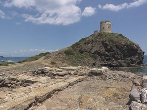
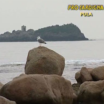
Nora is located on a promontory, the Cape of Pula, separated from the mainland by an isthmus that extends into two points: a O Sa Punta 'e Su Coloru (the tip of the snake), a E la Punta del Coltellazzo, in front of the homonymous island. The area is dominated by the Spanish Coltellazzo tower, in a position of great landscape value.
With the Roman conquest of Sardinia, which took place in 238 BC, the process of Romanization of the island was triggered. This process, which took place not automatically but punctuated by a complex structure in phases, was at the beginning strongly conditioned by the deep roots of Phoenician-Punic culture.
This situation can also be found in the urban planning of the island's urban centers, which for a long time remained based on the pre-existing Punic scheme. To explicitly inform us about the statute acquired by the city of Nora is the inscription of a base statue dedicated to Quintus Minucius Pius, which attributes to this character the title of “quattorvir iure dicundo”: this shows that Nora had reached the rank of “Municipium” certainly in the first half of the first century AD (this is the date of the base), but probably already in the Augustean age. The base was found in the area of the hole, where it had been reused as an element of the road pavement.
Finding archaeological information relating to the first phase of the history of Roman Nora is made rather complex by the intense urban attendance that affected the city, especially in the imperial age, inevitably changing its original structure.
The structures visible today are mainly relevant precisely at this stage. In fact, it was starting from the first century AD that Nora experienced significant urban development and an increase in human presence in its territory, as attested by the villas, necropolises and villages highlighted by archaeological research.
Between the second and third centuries AD, the city reached a significant degree of urban development and commercial traffic, while its decline began in the second half of the fifth century AD, as documented by the buildings of this period where there is the reuse of building material obtained from abandoned structures.
However, the ongoing excavations are progressively returning valuable information both on the late phases, on the Republican Nora, and finally on the previous Punic and Phoenician phases.
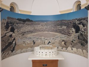
The city now appears to be arranged roughly in the center of that sort of triangle defined by the promontory of Capo di Pula at S the Punta del Coltellazzo at E and N from the isthmus that connects the peninsula to the hinterland (at its lowest point it measures 80 m). On the upper side of the triangle, oriented according to the O/E axis, there are several residential areas in succession, the “small baths”, the “macellum/horreum”, the so-called “temple of Tanit” and, at the end of the side, the theater and the forum. Continuing beyond the hole, towards the height of the Coltellazzo, we arrive at an area that the excavations in progress now have a sufficient degree of certainty to define as sacred.
Turning now to the side that connects Punta del Coltellazzo with the Cape of Pula, there are other important structures: the “central baths”, other residential areas and, closing on the side, the temple of Eshmun-Esculapio. On the remaining side that connects the Cape of Pula with the N-shaped area, currently under military control, there is a significant residential area, the “seaside baths” and, in closing, the Christian Basilica.
Based on archaeological evidence, the most plausible location of the port seems to be that of the natural gulf transformed into a pond in 1957.
History of excavations
The first interventions on the site, in 1889, concerned the tofet, while in the following years the Punic and Roman necropolises and small parts of the town were excavated. After other modest interventions, between 1952 and 1960, Gennaro Pesce highlighted a large part of the Roman town. Since 1990, the site has been affected by continuous systematic excavations by a group of universities.
Bibliography
P. Meloni, Roman Sardinia, Sassari, Chiarella, 1990;
S. Angiolillo, The Art of Roman Sardinia, Milan, Jaca Book, 1998;
Research on Nora - I (years 1990-1998), edited by C. Tronchetti, Cagliari, Saines, 2000;
Research on Nora - II (years 1990-1998), edited by C. Tronchetti, Cagliari, Sainas, s.d.; C. Tronchetti, Nora.
Sassari, C. Delfino, 2001 (Archaeological Sardinia. Guides and itineraries; 1);
Nora, C. Savi area 1996-1999, edited by B.M. Giannattasio, Genoa, Brigati, 2003;
A. Mastino, History of ancient Sardinia, Nuoro, Il Maestrale, 2005.
How to get there
From Cagliari, follow the SS 195 to Teulada up to km 27, where you turn toward Pula. After crossing the town and taking Via Nora, you arrive at the archaeological area after 3 km.
Content type:
Archaeological complex
Archaeology
Province: Cagliari
Common: Pula
Macro Territorial Area: South Sardinia
POSTAL CODE: 09050
Address: viale Nora, s.n.c.
Telephone: +39 070 9209366
Update
Where is it
Pula, Città romana di Nora Images number: 10
Texts
Video


Comments