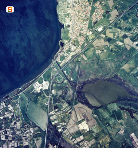
The ancient site was located in the territory of today's Santa Giusta, a small town overlooking the homonymous lagoon, near the Gulf of Oristano.
Othoca extended over a stubby promontory projected onto the lagoon, which at that time must have appeared as a vast and deep gulf that was completely navigable. The internal port basin was located in the N/E bend of the body of water, as revealed by the seabed that has returned numerous commercial amphorae dating back to between 700 BC and the late Republican era.
The foundation of Othoca dates back to the second half of the 8th century BC, according to what emerged from the excavations carried out in the 90s of the twentieth century on the height of the cathedral of Santa Giusta, where the town was located. Research in the crypt and in the S sector of the church's churchyard has in fact returned important data on the archaic facies of the settlement, which is superimposed on the structures of a recent Bronze and early Iron Age nuragic center.
The excavations revealed a double-walled wall, 2.70 m thick, which was attributed to the VII-VI century BC (not everyone shares this date and takes it to the 4th century BC, like the other Punic walls in Sardinia). The filling of the outer moat of the curtain returned important Phoenician production materials from the second half of the 8th century BC (plates, urns, fairing cups, the bottom of a plate with the representation of a bird in late geometric style) and from the first decades of the 7th century BC (“tripod bowl” with a rim decorated with a red band).
The Othoca necropolis, which returned materials from the second half of the 7th century BC to the beginning of the 6th century BC, extended to the south of the town, in the area of the current church of Santa Severa. It documents the rites of cremation, which is prevalent, and of burial. The tombs are of various types: a caisson, with a rectangular pit covered with sandstone slabs; a lithic cyst, with a clay urn placed inside a square cist in sandstone slabs; a circular, elliptical, rectangular pit. The sets, which often feature imported Greek and Etruscan vases, document the commercial opening of the settlement. The deceased from a grave grave, perhaps an urban Sardinian, was cremated with weapons: a spear, a dagger and two stilettos.
In the Punic Age, the city declined, even if it seemed to wake up in the 4th century BC, a period to which two important chamber tombs discovered in the nineteenth century are traced back. There is not enough data for the Punic period to reconstruct the topography of the center.
During the Roman era, as witnessed by the “Itinerarium Antonini” (3rd century AD), Othoca had to develop in relation to its character as a traffic hub: in its territory the two major roads “at Tibulas Sulcis” and “at Turre Karalis” were unified. Two bridges were built there, one of which, originally with five arches, remains a central arch and two smaller arcatelles to the south of the town, on the Palmas River (Su Pontixeddu).
The urban planning of the Roman city is unknown, but the discovery of colored plasters and mosaic tiles in the excavations of the cathedral, and the bare material reused inside it, suggest the existence of Roman buildings with elevations characterized by columns and porches.
History of
excavations The first archaeological investigations of Othoca, cited in numerous Roman sources, are due to Giovanni Busachi, an antiquarian who, starting in 1861, made discoveries in the southern suburbs of the town. Around 1892, lawyer Efisio Pischedda obtained an excavation concession, thus significantly increasing his archaeological collection (currently on display at the Antiquarium Arborense in Oristano). In 1910, the research of Antonio Taramelli and Filippo Nissardi took place. After a long pause, starting in 1983, the investigations resumed by Giuseppe Pau, Giovanni Tore and Raimondo Zucca. Recent excavations in the necropolis are due to Carla Del Vais and Emerenziana Usai.
Bibliography
R. Zucca, “The Phoenician-Punic Center of Othoca”, in Journal of Phoenician Studies, 9, 1981, pp. 98-113; G. Tore-R. Zucca, “Testimonia Antiqua Uticensia (Research in Santa Giusta-Oristano)”, in Sardinian Historical Archive, 34, 1983, pp. 11-35;
F. Fanari, “Archaeological findings in the Santa Giusta pond”, in Notebooks of the Superintendence of Cagliari and Oristano, 5. 1988, pp. 97-108; G. Nieddu-R.
Pumpkin, Othoca. A city on the lagoon, Oristano, S'Alvure, 1991;
R. Zucca, Journey into the Archaeology of the Province of Oristano, Oristano, E.P.T. Oristano, 2004;
C. Del Vais, “The Necropolis of Othoca (Santa Giusta-Oristano)”, in Emporikòs Kólpos, Oristano, 2005, p. 49; C. Del Vais-E. Usai, “The Othoca Necropolis (Santa Giusta-OR): excavation campaigns 1994-95 and 1997-98. Preliminary notes”, in Proceedings of the V International Congress of Phoenician and Punic Studies, edited by A. Spanò Giammellaro, Palermo, 2005, pp. 965-974.
How to get
From Oristano, take the SP 56 to the S of the city, up to Santa Giusta.
Content type:
Archaeological complex
Archaeology
Province: Oristano
Common: Santa Giusta
Macro Territorial Area: Central Sardinia
POSTAL CODE: 09096
Address: Santa Giusta
Update
Where is it
Images

Year : 1905
Results 2 of 122526
View AllTexts
Author : Bernardini, Paolo <1950-2018>
Author : Bernardini, Paolo <1950-2018>
Results 2 of 1419712
View All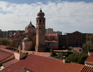
Comments