Subjects





Tharros is located at the southern end of the Sinis Peninsula. It unfolds in the Gulf of Oristano on a sort of natural amphitheater delimited to the north by the hill of Su Muru Mannu, to the west by that of the tower of San Giovanni and to the south by the isthmus that connects the latter to the promontory of Capo S. Marco.
Anonymous Ravennate, Giorgio Ciprio, Pseudo Probo and Sallustio are some of the ancient authors who mention Tharros; a rich epigraphic “corpus” in Greek, Punic and Latin is added to the literary sources.
A Roman city, perhaps handed over to the conquerors shortly after the end of the First Punic War (238-237 BC), but with a legal status that is not precisely definable, Tharros seems to be going through uncertain urban events, perhaps conditioned by a sort of economic recession, linked to the consequences that the transition to Rome had on changes in commercial routes, no longer determined by interests and relations with Carthage.
In the republican period, it had to take on the appearance of a Punic city in which the process of Romanization was slowly affirming itself, with cultural resistance and conservative traits, especially in the funerary custom, while with regard to urban and architectural interventions, it is not possible to fully measure the scale of the phenomenon, which is little documented if we exclude the reconstruction of the northern walls and the small style temple on the west side of the hill of San Giovanni.
A real monumental policy seems to be marked only with the reconstruction of the Phoenician temples and with the creation of the “Castellum Aquae”, as well as with the structuring of the basalt road network.
The city underwent strong urban conditioning in the imperial age, by the Flavians, the Antonines and the Severi. The most significant surviving stretch of road network is certainly the “cardo maximus” with a north-south trend and with the smaller roads that merge laterally, conforming to the geomorphological structure of the area.
On the eastern side of the peninsula, the port must have been located, now submerged and identified thanks to underwater surveys; the organization of the monumental area and the residential district, with peculiarities relating in particular to housing units, is of extreme interest, while the general layout of the town, adapting to the conformation of the land, does not provide any solution of continuity with respect to the Punic city.
Between the 3rd and 4th century AD, the city was invaded by a new urban phase with the restructuring and strengthening of defensive works linked mainly to the threat of vandalism.
Basically, it can be said that the urban structure of Tharros in Roman times follows the Punic structure of the 6th-5th century BC, with the inclusion of monumental buildings and above all with the re-functionalization of the port area.
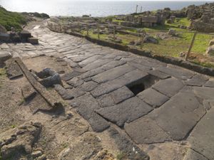
The visit to the Roman remains of Tharros can start with the channeling into 'opus mixtum', part of the city's water supply system, behind the church of San Giovanni. Then take the Roman road, with its typical basalt pavement, flanked by the remains of buildings.
After following the road, turn left for the “cardo maximus”. To the north, on the hill of Muru Mannu, there is a temple, perhaps dedicated to Demeter. Founded in the Punic era, it was transformed in Roman times into a tripartite structure with secondary rooms.
Then we arrive at the amphitheater”, a late-Roman circular structure surrounded by a cavea (m 32 x 30), and to the tofet with the emerging remains of the Nuragic village. Then you reach the northern fortifications that show a Punic phase and a Roman republican phase.
We walk backwards along the 'Cardo Maximus' reaching the 'Castellum Aquae', the city's main water tank. This is rectangular (13.8 x 11.5 m) and is built in “opus mixtum”; the interior, divided into three naves with 8 pillars, 4 of which are central, has a floor lined with coccio-pesto.
Moving along the road to the sea, you can see a residential district on the right; on the left you can see a mixed-work building that, due to the richness of the plastering, the presence of a well, the planimetric layout, is recognizable as a thermal complex: it consists of a rectangular environment on which two rooms open up that lead into apsidic environments.
Behind the baths, continuing and turning left after the 'temple of the Egyptian gorges', you can see another thermal building from the 2nd century AD; the dressing room, the 'tepidarium', the 'calidarium', and two rooms on which a tank was set up remain. To the north is the “ecclesia sancti Marci”, the center of an area with various early Christian testimonies.
Going back along the paved road to the south, you can admire the remains of the “monumental temple”, equipped with a powerful fence wall in isodome work on the NW and NE sides, and dug into the sandstone on the other sides (m 34 x 16). The first phase of the sanctuary dates back to the 4th/3rd century BC. A stepped ramp led to the rectangular altar; the rise was decorated with Doric half-columns. Next to the building, on the south side, a ritual tank opened.
Even further south, you reach the “temple with a Semitic plan”, with one of the four sides cut into the rock bench; it has a polychrome floor mosaic from the second century A.D. Then
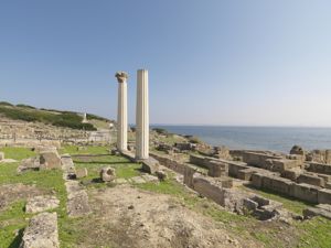
you reach the “area of the two columns”, one of which is dominated by a Corinthian-Italic capital. The area is full of remains that are difficult to identify, except for a small late-republican temple, with two pillars in the front and an access ramp of five steps.
To the south, the troubled stretch of coast is what remains of the port area. In the same direction, the “baths of the old convent” represent the richest thermal complex in the city, dating back to the end of the second century A.D. It is built of “opus mixtum” and brick and is arranged on three levels: from the “apodyterium” with a masonry counter and triangular housings, we move on to the “frigidarium” with two originally mosaic tanks; then to the three “calidaria” that highlight the “suspensurae” in bessals on which the floor rested.
To the north you reach the forum, a triangular square paved with basalt, with adjacent residential areas. The houses had an access compartment that the rooms faced. Sometimes there was an upper floor. The shops occupied a single environment.
To the south-west, there are structures in the form of a quadrilateral base (h res. m 3.50). An imperial Roman-era necropolis is located north of the Tofet beyond the Roman fortifications.
History of excavations
The investigations of the site began in 1838 by the Marquis Scotti and the Jesuit Perotti. In 1842, an excavation commissioned by the King of Sardinia Carlo Alberto enriched the royal collections of Turin with gold coins, jewels and scarabs. Thanks to the king, the prohibition of clandestine excavations aimed at illegal enrichment was obtained. In 1851, Lord Vernon, an Englishman who was on the 'Grand Tour' of Italy, dug 14 tombs in the underground chamber and, among other things, found many jewels, which he took with him to England. The discoveries aroused the interest of the inhabitants of nearby Cabras, who violated about 500 tombs. In 1860, the then director of the Cagliari museum, Gaetano Cara, discovered some Punic tombs containing rich items, which he stole and offered to the main museums in Europe, eventually selling them to the British Museum in London. From 1956 to 1964, Gennaro Pesce brought to light part of the town to the east of the tower of S. Giovanni and, to the north, the area of the tofet. Ferruccio Barreca, in 1958, identified the small temple at the end of Capo San Marco and, from 1969 to 1973, he continued the excavations of the town, the fortifications and the tophet. This last area was investigated in collaboration with Enrico Acquaro.
Bibliography by
G. Pesce, “Tharros”, in Encyclopedia of Ancient, Classical and Oriental Art, VI, Rome 1966, pp. 800-806;
E. Acquaro - C. Finzi, Tharros, series “Archaeological Sardinia. Guides and itineraries”, 5, Carlo Delfino, Sassari, 1986;
R.D. Barnett - C. Mendleson, Tharros. A Catalogue of Material in the British Museum from Phoenician and Other Tombs at Tharros, Sardinia, British Museum, London 1987;
M. Falchi, Analysis of the urban configuration of Tharros, in Tharros, edited by P. Desogus, Nuoro, 1991, pp. 23-37;
R. Zucca, Tharros, Oristano, G. Corrias, 1993; E. Acquaro, C. Finzi, Tharros, series “Archaeological Sardinia. Guides and itineraries”, 5, Sassari, Carlo Delfino, 1999;
C. Del Vais, The Third Life of Tharros the Plundered City, “Darwin. Notebooks”, n. 1 (July-August 2006), pp. 76-85.
How to get
There From the hamlet of San Giovanni di Sinis, continue towards S for about 1 km on SP 6.
Content type:
Archaeological complex
Archaeology
Province: Oristano
Common: Cabras
Macro Territorial Area: Central Sardinia
POSTAL CODE: 09072
Address: SP 6 - località Tharros, San Giovanni di Sinis
Website: www.tharros.sardegna.it/info-e-prenotazioni/orari-e-modalita-di-visita-di-tharros
Update
Where is it
Cabras, Città romana di Tharros Images number: 5
Images
Texts

Author : Madau, Marcello
Author : Madau, Marcello
Results 2 of 1554303
View All
Video


 Facebook
 Twitter
 LinkedIn
 Whatsapp

 Print
Print
 E-mail

Comments