The monument is part of a settlement located on the eastern edge of the plateau of Monte Baranta. The archaeological area is characterized by a defensive system consisting of the wall in question, which protects a part of the town with huts, and by a fency-tower, placed on the precipitous edge of the plateau.
The complex includes a fency-tower, a wall that encloses a town and a megalithic circle with menhirs.
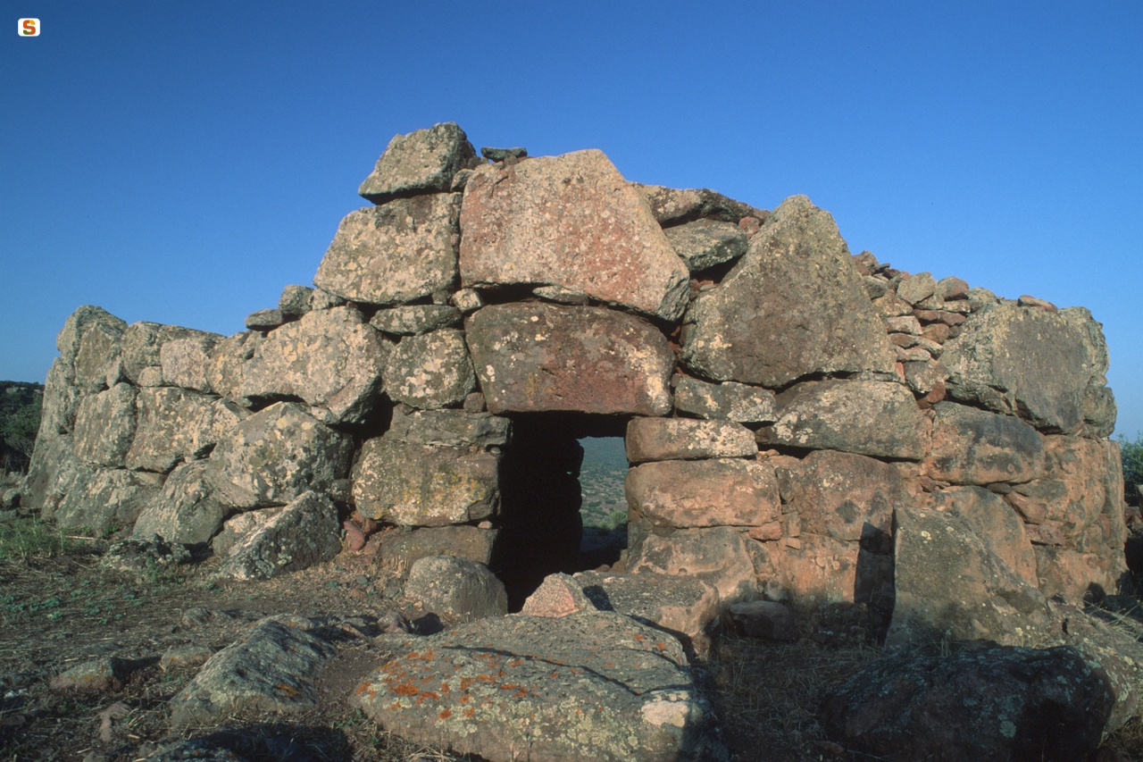
The horseshoe-shaped tower fence (rope m 20.65; arrow m 15.30; height 3.45 m), is built on the edge of the escarpment.
The wall of the fency-tower (thickness 4.14-6.50 m) consists of two walls: the outer one made of large trachyte slabs, superimposed with the aid of large reinforced wedges; the inner one built with smaller boulders, sketched and arranged in regular rows. The two walls are joined by a stone filling without any connecting element.
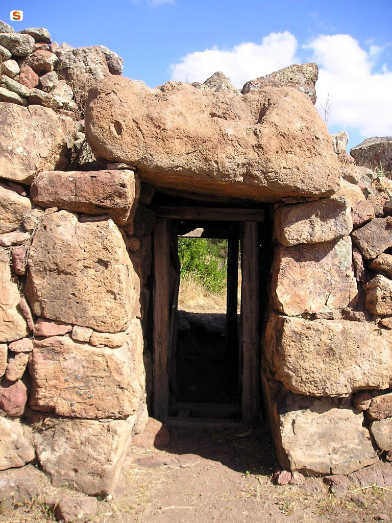
The enclosure, which delimits a large open-air courtyard, is accessible through two entrances (width 1.20 m; height 2.10 m; height 1.73 m), oriented N and W, which lead into covered, flat corridors.
The semi-elliptical courtyard (rope m 12.60; arrow m 9.75), has a ladder on the SO wall that leads to a sort of roundabout path (average width m 1.50) that goes around m 6, interrupting at corridor O. It is likely that, rather than for defense needs, staircase and “round trip” were functional to the support of wooden structures planted in the thickness of the wall.
In the inner wall of the building, in shape of the W, there is an elevated niche - now largely ruined - while on the N, above the corridor, there is a tower to defend the external entrance.
The courtyard floor, mostly made of natural rock, has sections regulated by stones.
About 100 m NW of the tower fence, in a higher position, there is a short rocky terrace defended by a powerful wall in the only unguarded section.
The curtain (length 97 m; height 1.48-3.00 m; thickness 3.75-5.00 m), straight for most of the route, with an NS orientation, bends inwards in the S section, in parallel with the rock profile. The wall, built with the same masonry technique as the fency-tower, has only one N-shaped entrance (width 0.65 m; residual height 1.70 m), close to the escarpment, which leads into a rectangular corridor (length 5.10 m; width 0.90 m; height 1.60 m) today under the open sky.
The inner wall of the wall, near the corridor, is supported by a staircase consisting of a single-row wall, with a scalar profile. There is no trace left, vice versa, of the patrol journey.
In the inner E-shaped area of the wall, there are numerous rectangular huts, sometimes apsed (m 5.82 x 6.40; height 0.80 m); the rooms are often partitioned and the floors rest on a crawl space of small stones or are paved.
Outside, a few meters W of the wall, there is a megalithic circle (diam. m 10) delimited by about eighty slabs of various sizes, including some menhirs, today broken or scattered on the ground.
About ten meters NW, isolated and landed, there is a larger dense stone (length 3.95 m); it is a monolith that has never been erected: on the rock plane, in fact, the engraved box of the alveolus that should have contained the base of the monolith has been found and the menhir itself appears not yet finished.
The materials found during the excavations refer to the Chalcolithic culture of Monte Claro (2400-2100 BC), a period to which the construction of the complex dates back to. The site was inhabited for a rather short period, as the scarce amount of finds dating back to this phase of occupation and the failure to complete the sacred area seem to document.
The site was later visited in the ancient Bronze Age (1800-1600 BC) - limited to the fency-tower - and to a more sporadic extent in the Nuragic and Roman ages.
History of the excavations
It was excavated in 1980 and 1981 by Alberto Moravetti.
Bibliography
E. Contu, “The Monte Baranta Nuraghe in 'Su Casteddu' or 'Pala Reale' (Olmedo-Sassari)”, in Studi Sardi, XVII, 1959-61, pp. 640-641;
A. Moravetti, “Note to the excavations of the megalithic complex of Monte Baranta (Olmedo-Sassari)”, in Journal of Prehistoric Sciences, XXXVI, 1982, pp. 281-290; A. Moravetti, The Prenuragic Complex of Monte Baranta, series “Archaeological Sardinia.
Guides and Itineraries”, Sassari, Carlo Delfino, 2000;
A. Moravetti, Monte Baranta and the culture of Monte Claro, series “Archaeological Sardinia - Excavations and Research”, 3, Sassari, Carlo Delfino, 2004.
How to get
From Olmedo, take the SP 19 road in the direction of Alghero for about 1.2 km, then turn left, following the tourist signs, along a dirt road and follow it for 850 meters. Once you reach the parking area, a pedestrian path, about 700 m long, will lead to the plateau where the archaeological complex develops.
Content type:
Archaeological complex
Archaeology
Usability: unmanaged site
Province: Sassari
Common: Olmedo
Macro Territorial Area: Nord Sardegna
POSTAL CODE: 07040
Address: strada comunale Olmedo-Uri, località Monte Baranta
Update
Where is it
Olmedo, Muraglia di Monte Baranta Images number: 5
Images
Texts

Comments