The archaeological area is located on the vast plateau of Moddizzi or Giba sa Siliqua, bounded to E by the granite ridge that develops parallel to the Costa Rei, in the Sarrabus, region of south-eastern Sardinia.
The menhirs of Nuraghe Scalas are located about 200 m from the top of the rocky relief on which the homonymous protonuraghe stands. They are 43 and are arranged in groups and alignments of 3, 4 or 5 elements. Fixed deep in the ground, they have a height ranging from 2.00 m to 1.00 m; the average width is 0.60/0.70 m. They mostly show a triangular, square, or rectangular section. The menhirs 1 and 2, larger than all the others and, perhaps, the only anthropomorphic ones, located at a mutual distance of 1.80 m, were installed with a symmetric inclination.
These monoliths were studied using an electronic computer and a mechanographic procedure aimed at identifying the methods of use and the purpose of building the group.
The results of the investigation suggest that the menhirs acted as a stone calendar for the identification of seasonal cycles; daily correlations have also been highlighted that allow constant monitoring, throughout the solar year, of the rising and setting of the sun and the moon.
Surface surveys carried out in the area of the megalithic complex have led to the discovery of some obsidian tools (blades, scrapers) and ceramic fragments attributable to the Ozieri culture of the late Neolithic (3200-2800 BC). The finds were associated with materials from the Nuragic and Roman imperial periods.
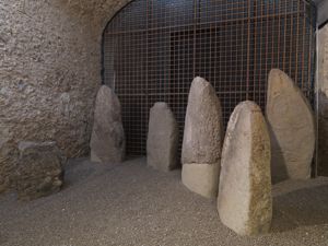
Another megalithic complex, in the town of Cuile Piras, has been studied with the same procedures used for the Nuraghe Scalas monoliths. The Cuile Piras complex is composed of 53 menhirs arranged in an alignment of 3-5 elements around a central cluster. The monoliths, still in their original orthostatic position, have been related to the positions that the sun and the moon assume at sunrise and sunset.
At the central group, ceramic materials from the Ozieri culture, from the late Neolithic (3200-2800 BC), were collected.
History of excavations
The menhirs were studied mainly in the context of a 1985 archaeological census.
Bibliography
R. Ledda, Megalithic monuments of southeastern Sardinia. Archaeological census in the territory of the municipality of Muravera, Quartu Sant'Elena, ESA, 1985, pp. 198-205.
How to get
From Muravera, head towards Castiadas; after San Priamo, at the height of Olia Speciosa, turn left for Costa Rei. At the end of the long straight line that runs along the edge of the Pranu Malloccu plain, after about 2-2.5 km, just before the start of the curves, you turn right into an agrarian road that leads to the Toneddu houses. Continue for about 1.5 km, passing the farm, until you reach the foot of the Nuraghe Scalas hill, where the menhir complex is located.
Content type:
Archaeological complex
Archaeology
Usability: unmanaged site
Province: South Sardinia
Common: Muravera
Macro Territorial Area: South Sardinia
POSTAL CODE: 09043
Address: località Costa Rei
Update
Where is it
Images
Texts

Author : Fedele, Francesco G.
Author : Fedele, Francesco G.
Results 2 of 1292008
View All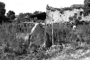
Comments