The archaeological area is evocatively integrated with the natural element and is located on a granite tower partially surrounded by the Tèscere river, in the inner part of Ogliastra.
The complex includes a nuraghe with an adjoining village and two domus de janas.
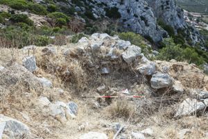
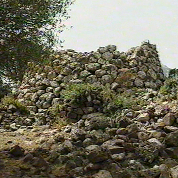
The nuraghe is of a complex type, with a main tower to which another body has been added at a lower altitude (length m 48; width m 36; residual height m 5).
The building is made of medium-sized square granite blocks; they are arranged at the base in polygonal work and in the upper parts in rows regulated with the aid of reinforced wedges.
The main tower, with a circular plan (remaining height 4.70 m), has an entrance facing S/E surmounted by a well-worked lintel.
The entrance leads into a rectangular entrance that leads to the inner, eccentric, circular room (height about m 2). On the same entrance, on the left wall, there is access to the stairwell, which is currently not accessible.
The added body is accessible through an entrance facing N with a trapezoidal light and surmounted by an lintel (m 2.60 x m 0.75 x m 0.45) that leads to a curvilinear corridor.
This passage is now cluttered with collapsing material and has on the walls the non-coaxial entrances to two niches: the upstairs one has a rectangular plan, while the upstream one is filled with earth and boulders.
Also on the d. side, the arched entrance to a corridor, currently impassable, opens.
The nuraghe was defended by an antewall, built at a lower altitude, which had to be set to S on the added body, integrating various rock emergencies.
The entrance, located in the E direction, is currently partly hidden by earth and stones.
The nuraghe is characterized by the presence, under the main tower, of some natural cavities sometimes integrated by wall structures.
The archaeological area also has an extensive village attached to the nuraghe and, a short distance to W from this, two domus de janas. The two hypogeic burials are dug into two erratic boulders.
The first single-celled domus is accessible through an elevated entrance preceded by a short pavilion. The trapezoidal hatch (width m 0.48; height m 0.52), is equipped with a built-in frame. The room, rather small (depth 1.10 m; width 0.85 m; height 0.85 m), has an oval plan with an oven vault.
In the area in front, some fragments of a carefully worked granite slab have been found: these are, perhaps, the remains of the door cover.
The second hypogeum has a single room devastated by the sagging of the forehead of the boulder where the entrance opened. This, raised, was made in the back wall of a small pavilion. The hatch, without recess, lacks the jamb that came off following the collapse. The cell has carefully polished walls and floor.
History of excavations
The first investigations date back to 1994; a recent excavation was carried out in 2003.
Bibliography
V. Angius in G. Casalis, Historical-Statistical-Commercial Geographical Dictionary of the States by H.M. the King of Sardinia, VIII, Turin 1841, p. 454; A. Taramelli, “Anecdotes and news.
Archaeology”, in Archivio Storico Sardo, 1905, p. 749;
G. Vacca, Geographical position of the main nuraghi of Sardinia, Cagliari, Sarda Typographic Society, 1917, p. 20; G. Lilliu, I Nuraghi.
Prehistoric Towers of Sardinia, Cagliari, La Zattera, 1962, pp. 153-154;
E. Melis, Map of the Nuraghi of Sardinia: prehistoric monuments in the town of Mamoiada, Spoleto, Panetto & Petrelli, 1967, p. 128;
V. Santoni, “Preliminary note on the type of artificial funerary caves in Sardinia”, in Sardinian Historical Archive, XXX, 1976, pp. 18, 43;
F. Cocco, “Ilbono”, in Data relating to the history of the countries of the Diocese of Ogliastra, 1985, p. 6; E. Contu, “The Nuraghe”, in Civilization
nuragica, Milan, Electa, 1990, p. 60; Nuraghi
project: archaeological survey in Ogliastra, Barbagia, Sarcidano, Milan, Archeosystem Consortium, 1990, pp. 226-229.
C. Nieddu, “Scerì Monumental Complex”, in C. Nieddu (edited by) Archaeological Sites of Ogliastra, Tortolì 2006, pp. 34-35.
How to get
From Tortolì, take the SS 198 in the direction of Lanusei; you travel about 5 km and, before arriving at the Baunuxi border, turn upwards into a road marked by an old tourist sign for the archaeological area. Continue until you reach a gate, open during visiting hours. You pass it and continue for a few hundred meters until you reach the site.
Content type:
Archaeological complex
Archaeology
Usability: unmanaged site
Province: Nuoro
Common: Ilbono
Macro Territorial Area: Central Sardinia
POSTAL CODE: 08040
Address: SS 198 - località Scerì
Update
Where is it
Images
Video
Audio


Comments