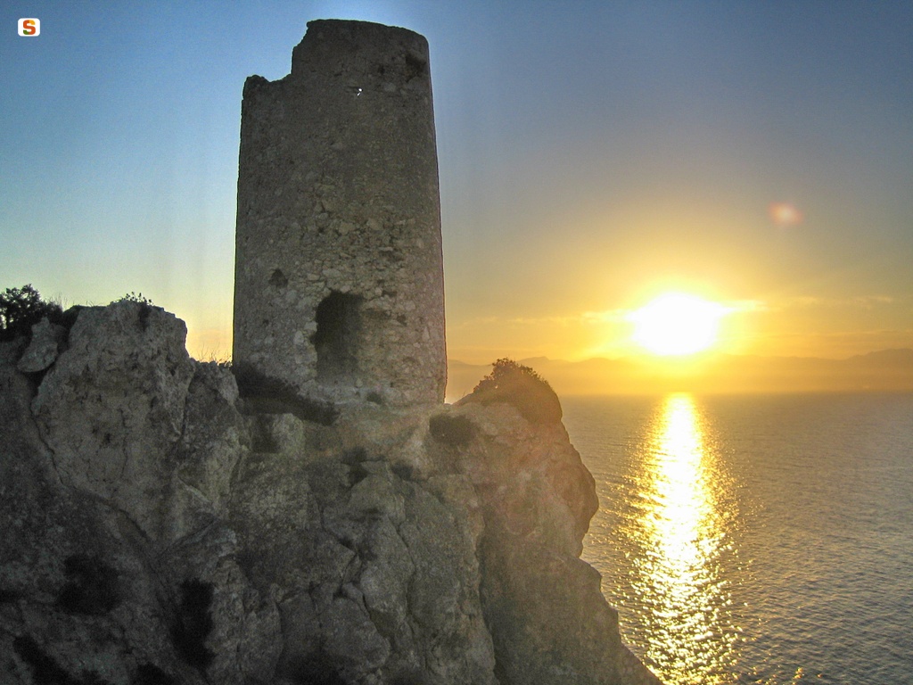
The tower guarded the beach below and the Lazzaretto area, to report any incursions into the salt marshes. He was also in visual contact with the nearby towers of Calamosca, Cala Fighera, Sant'Elia and the fortifications of Cagliari. Being about 34 m above sea level, it had an optical range of about 23 km.
The name of the tower varied over the centuries, starting with the toponym 'Cape Bernat' or even 'Cala Bernat' or 'San Bernardo' in Spanish times. In the 18th century it was called “di Santo Steffano called del Lazzaretto”, “de la Prajola” (of the beach), “Old Woman” in the 20th century. The current name “del Prezzemolo” or “de su Perdusemini” or “Petro Semolo”, already attested in the 18th-19th century, is actually borrowed from the tower of Cala Fighera, as shown by a document from 1740.
In 1578, it was reported that there were two towers, one in Calamosca and one in Capo Bernat, maintained at the expense of the city of Caller. The construction of the tower dates back to that time. But already in 1597, a few years after its construction, the Cape Bernat tower was being restored. At the time, the garrison consisted of two torrieri. A further restoration took place in 1605, when a small hanging balcony was placed in the entrance. In 1606 and 1615, the garrison was increased. The tower is present in the Spanish map of the Simancas Archive dated 1625.
The Prezzemolo tower is a building with a classic truncated conical shape but small in size. Among the coastal towers, it is the smallest, with a foundation diameter of just 4.5 m and a remaining height of 11 m. This is due to the distress of the site where it was built, a rocky spike with access from a single direction, close to the cove below. The tower, intended only for the sighting function, was defined as 'torrezilla'.
Like the other Cagliari towers, the internal room had a single opening that corresponded to the entrance. This is made with pebbles and stone lintels, about 4 m above the ground. Through a hatch in the domed vault, one could reach the parade ground, that is, the external terrace, in turn covered by a crescent (a shed made of reeds and tiles used to shelter soldiers and ammunition, shaped like a semicircle).
In 1638, following the entry into operation of the nearby tower of Calamosca, it was discharged and will no longer appear in the official acts of the 17th and 18th centuries. In reality, a tower of Lazzaretto appears in the report by Cagnoli, First Commissioner of Artillery, Factories and Fortifications, in 1720. However, only in 1772 was it considered to rearm it as a staging post for riflemen and for the support of a light infantry company.
On the occasion of the French attack of 1793, the engineer Lorenzo arranged a small battery of cannons close to the tower, thanks to which the landing on the beach below was prevented. After this episode, however, the tower was permanently abandoned. In December 1916 it was restored and in 1967 the rock on which it stands was shored, to prevent it from falling apart.
Bibliography
P. Marini, “The French expedition for the conquest of Sardinia in 1793", in Archivio Storico Sardo, XVIII, fasc. II-III, 1931;
E. Pillosu, The coastal towers in Sardinia, Cagliari, La Cartotecnica Typography, 1957;
F. Fois, Spanish Towers and Piedmontese Forts in Sardinia, Cagliari, La Voce Sarda, 1981;
G. Montaldo, The coastal towers in Sardinia, Sassari, Carlo Delfino, Sassari 1992; F. Segni Pulvirenti-A.
Sari, Late Gothic and Renaissance-influenced Architecture, Nuoro, Ilisso, 1994, sch. 21;
M. Rassu, Guide to coastal towers and forts, Cagliari, Artigianarte, Cagliari 2000.
Content type:
Fortified architecture
Province: Cagliari
Common: Cagliari
Macro Territorial Area: South Sardinia
POSTAL CODE: 09126
Address: via Borgo Sant'Elia
Update
Where is it
Images

Comments