The Roman bridge called “Sa Baronessa” is located inside a privately owned cultivated field, at a distance of about forty meters to the east from the Flumini Mannu riverbed, about nine km north of the town of Pabillonis, just over a km from the rural church dedicated to San Lussorio.
The ruins of the Roman bridge called “Sa Baronessa”, an appellation assumed only in the second half of the 19th century but known in the previous official cartography as “Ponte Vecchio” or “Ponte di Santa Caterina”, are located inside a cultivated field in a private area, at a distance of about forty meters to the east from the Flumini Mannu riverbed, with respect to which it is not perpendicular, but oblique: this fact is explained by modern channeling and rectification works that have completely altered the original course of the river.
According to the most accredited interpretations of scholars, the bridge was functional to traffic between the Punico-Roman city of Neapolis and the internal areas of the “Neapolitanum territory”, located at an important ford controlled, starting from the Bronze Age, by two nuraghi located on opposite banks and, about six hundred meters away, also from the Nuraghe Santu Sciori, located in the territory of Pabillonis, where an important village was built in the Roman Age.
The monument is located between the first century BC and the fifth century AD.
The monument is currently partially obscured from view in its northwestern portion due to the dense vegetation that surrounds it, while the opposite side is free and perfectly visible: two pylons are preserved in optimal conditions, built with large and medium-sized parallelepiped basalt blocks, perhaps recovered from older buildings, of which three rows are visible tied with lime mortar and stuffed with stone chips plus small.
A low-profile arch is placed on the basalt stones, with the archive consisting of a ring built with parallelepiped blocks of shale, also tied by a tenacious mortar that, in the intradossus, also served as plaster and of which there are still some traces left. On the estradox, the road plan is still visible in good condition, consisting of pebbles of various kinds and sizes, drowned in the mortar, while few traces of the original parapet remain. Around the monument, other structures or torn walls are not recognizable, either pertaining to the bridge or to buildings connected in any way to it.
The bridge has significant injuries in the middle part of the arch, so there is a danger of collapse if consolidation works are not carried out.
History of excavations and studies
The first certain mention attributable to the Roman bridge of Pabillonis can be found in a nineteenth-century cadastral map of San Nicolò Arcidano, then in a dispute over the definition of borders with the municipalities of Mogoro, Pabillonis and Guspini, in which the toponym of “Ponte Vecchio or Santa Caterina” on the right side of the river, which faces an unidentified “Nuraxi Fogoneddu” on the right side of the river, which faces the opposite bank of an unidentified “Nuraxi Fogoneddu” later never again attested by the sources.
The name “Ponte della Baronessa” comes later, after Baron Rossi, owner of that area, received this title in 1847.
In 1987, Honorary Inspector Tarcisio Agus reported the risk of the bridge collapsing, and a consolidation operation was hoped for.
The monument was affected in 2017 by a security intervention carried out by the Municipality which, during routine maintenance and cleaning of the area, had detected the state of insecurity of the structure.
Bibliography by
F. Floris, The Great Encyclopedia of Sardinia, Sassari 2007, pp. 800.
Tarcisio Agus, Subject: Dangerous Roman bridge in the countryside of Pabillonis, in the current archive of the Superintendence for Archaeological Heritage for the provinces of Cagliari and Oristano, prot. 2779, 16/05/1987.
F. Fois, The Roman Bridges in Sardinia, Sassari 1964, pp. 36-38.
G. Lilliu, Archaeological Newsletter, in “Sardinian Studies”, Sassari 1948, n. VIII, fasc. I-III, pp. 412-460.
Military Geographic Institute, sheet 225 of the Charter of Italy IV - N.E. CASA ZÈPPARA, year 1898.
Royal Corps of Staff, “Maps” series, Unit: San Nicolò Arcidano “Union sheet of the Municipality of San Nicolò Arcidano”, Cagliari, December 31, 1843.
How to get there
The Roman bridge “Sa Baronessa” is located about 8 km north from the town of Pabillonis, a short distance from the rural church of San Lussorio. From the town, from Via Gramsci, take the SP 4; go for about 7 km then turn right and continue on the SP 98 for 500 m., then on the right again take a consortium road. After traveling another 500 m, the bridge is visible on the left.
Content type:
Archaeological monument
Archaeology
Usability: unmanaged site
Province: South Sardinia
Common: Pabillonis
Macro Territorial Area: South Sardinia
POSTAL CODE: 09030
Address: SP 98 - località Ponte della Baronessa
Update
Where is it
Pabillonis, Ponte romano Images number: 5
Images
Texts

Author : Dal_Piaz, Giorgio <1872-1962>
Year : 1957
Author : Dal_Piaz, Giorgio <1872-1962>
Year : 1957
Results 2 of 1277874
View All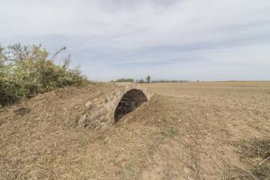

Comments