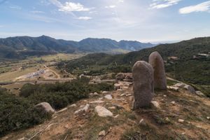
The archaeological site is at the foot of the S side of Monte Arci, on a hill that dominates the upper course of the Mogoro River (Riu Funtana Canna, in this stretch), in the hinterland of the Gulf of Oristano.
The complex includes a menhir and two small domus de janas.
The menhir, known by the name of Su Furconi de Luxia Arrabiosa, stands isolated on a short plateau; around it there are other slabs that have been landed, and stones dug into blocks of calcareous marl, a sign of a visit to the site in Roman and late ancient times.
The menhir is quadrangular in shape, thinned at the top in an almost conical shape, and measures 3.60 m in height. On the main face, facing E, 12 small cups, or recesses, are sculpted along a vertical longitudinal line set at the center of the stone, but with a discontinuous, almost zig-zag pattern, in which four broken segments, each consisting of three cups, follow one another. The recesses, circular, have diameters ranging from 2 to 3 cm, and are about 1.5 cm deep. Around the menhir area, and on the path that goes up to the plateau, numerous fragments of obsidian are found.
The domus de janas known as “Su Forru de Luxia Arrabiosa” is located about 500 meters N of the menhir. It consists of three cells arranged on a longitudinal axis; the entrance, facing SO (door of m 0.58 x 0.60), leads into the antecell (m 1.80 x 1 x 0.70 h.) with a vault; the main cell measures m 2.20 x 1.60 x 1.70 in height, while the last cell (perhaps an elevated niche of m 0.10) measures m 1.30 x 0.80 x 0.60 in height. Cornelio Puxeddu found numerous obsidian instruments there, while outside he also noticed the presence of textured ceramics. The second tomb, known as “Su Stabi de Luxia Arrabiosa”, is much simpler and less accurate in workmanship: it consists of a single room with an irregular layout.
The complex can be traced back to the final Neolithic (culture of Ozieri, 3200-2800 BC), Eneolithic.
History of the excavations
The menhir was already known to La Marmora in the nineteenth century, but he mistakenly attributed it to Ales, indicating it with the incorrect name of “Lucia Rajòsa”. The area is currently affected by development work.
Bibliography
A. La Marmora, Voyage en Sardaigne ou description statistique, phisique et politique de cette ile avec des recherches sur ses productions naturelles et ses antiquités, translates. V. Martelli, Cagliari, The Nuraghe, 1926-28, p. 8, pl. II,4;
G. Lilliu, “New Well Temples of Nuragic Sardinia”, in Studi Sardi, XIV-XV, 1955-57, p. 93 ff., note 97, fig. 10.1;
C. Puxeddu, “Prehistory and Romanization”, in The Diocese of Ales-Usellus-Terralba, Aspects and Values, Cagliari, Fossataro, 1975, pp. 94-95, 100.
How to get there
You leave Morgongiori in the direction of Ales and immediately turn right into a recent municipal road that branches off from the SS 442, just beyond the cemetery; after about 350 meters, turn left and, after another 350 m, still left. Continue along the municipal road for about 1150 meters: just before a bridge, you leave the car and proceed on foot (or off-road) along a path, on the right. After more than a kilometer, the dirt road goes up the slope to the left; the archaeological area begins on the hill, located on the plateau on the left.
Content type:
Archaeological complex
Archaeology
Usability: unmanaged site
Province: Oristano
Common: Morgongiori
Macro Territorial Area: Central Sardinia
POSTAL CODE: 09090
Address: località Pranu Ante
Website: www.morgongiori.eu/index.php?option=com_content&view=article&id=29&Itemid=140
Update
Where is it
Morgongiori, Necropoli e menhir di Prabanta Images number: 5

Comments