The necropolis is located on the N edge of the limestone plateau of Coros, which dominates the Mannu River valley, in Logudoro, a region of northwestern Sardinia.
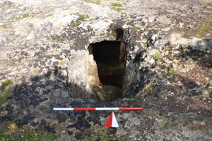
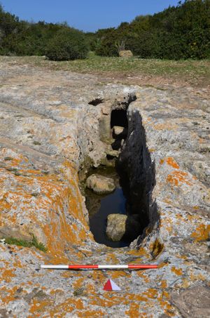
The necropolis includes 11 hypogeums: domus de janas and “domus with an architectural perspective”. Tomb I was originally composed of five chambers, now a single room for the removal of the dividing walls. A circular anticell (m 1.52 x 1.40 x 1.10) - with walls decorated with vertical panels framed by pilasters and a band at the base - leads to the main cell, originally rectangular, on which three rooms arranged in a cross were opened: the one had two raised niches. Tomb II is a domus restored as an “architectural tomb”. The original burial consisted of a small antecell and a main cell to which two secondary rooms now gathered in a single room opened up on the ground and at the bottom.
On the rocky front, the exedra (rope m 6.00; arrow m 2.00) was reproduced, excavated and covered with orthostatic plates. A curved stele was placed in front of the entrance door, of which two fragments of the lower part are preserved. Above the rock bank, there is a mound delimited by orthostats (length 10.40 m; width 4.00/2.80 m). Tomb III was originally composed of a short pavilion, an antechamber and a cell with four secondary rooms, later transformed into a single large room. In the Nuragic age, the exedra was built, excavated on the rocky front (rope m 6.00; height m 1.00) and covered with orthostatic slabs. At the center of the hemicycle stood a stele, of which the upper lunette (width 2.00 m, height 1.80 m; thickness 0.22 m) is preserved, lying on the ground in front.
Tomb IV is rebuilt. It has the exedra on its forehead - the s. wing is not completed - with the bipartite stele in the center (width 3.20 m; height 3.20 m). On the top of the rock front, there are three truncated conical holes and a trapezoidal mound (length 8.80 m; width 2.80-2.00 m; height 1.50-1.30 m), perhaps originally apsidated. The large burial chamber is circular (diam. m 6.00; height 2.00 m) and has an oven-shaped ceiling.
Tomb V is dug on an erratic boulder that seems to reproduce a rectangular mound (length m 1.72; width m 2.70; height m 2.00) shaped like a barrel. The burial chamber is rectangular. Tomb VI, renovated, has a large room that leads to three smaller rooms. On the rocky front, the exedra originally covered with slabs was reproduced. Tomb VII, newly built and excavated on a large rock wall, reproduces the exedra (rope m 7.00; prof. m 0.70) with wings of decreasing height towards the sides (height m 2.70). The mound is built on the top. Inside there is a single trapezoidal compartment - with five recesses, a rectangular band and a square - preceded by a short corridor. Tomb VIII, newly built, preserves the representation of the stele on its forehead. A brief passage leads into the burial compartment. Tomb IX, multi-celled, was damaged by the construction of Tomb IV. It consists of a 'dromos', an anticell with a dimple and a cell on which secondary compartments open (under excavation). Tomb X is single-celled with a cockpit entrance, while Tomb XI is barely identifiable.
The complex can be framed between the late Neolithic and the Middle Bronze Age.
At the necropolis there is a nuraghe (protonuraghe?) It is a megalithic circle made of orthostatic boulders, which delimits a semicircular cultural area close to the precipitous edge of the plateau. The materials found are characteristic of the eneolithic culture of Monte Claro. A little further downstream are the domus de janas of Ochila, some richly decorated with symbolic and architectural elements in relief.
History of the excavations
It was excavated by Ercole Contu in 1961. New excavations have been carried out since 2001 by Paolo Melis.
Bibliography
E. Contu, “Newsletter”, in Journal of Prehistoric Sciences, XVI, 1961, pp. 275-276;
E. Castaldi, Domus nuragiche, Rome, De Luca, 1975, pp. 36-38;
E. Contu, The meaning of the “stele” in the tombs of giants, series “Notebooks. Archaeology and Conservation”, edited by F. Lo Schiavo, 8, Sassari, Dessì, 1978, pp. 16, 20, 52, 66-67;
P. Melis, “The Hypogeic-Megalithic Complex of Sa Figu - Ittiri (SS)”, in Aspects of Prehistoric Megalitism, edited by G. Serrali-Vacca, Dolianova, Grafica del Parteolla, 2002, pp. 9-12; P. Melis, “The Hypogeic Necropolis of 'Sa Figu' - Ittiri (Sassari)”, in Studies in honor of Ercole Contu, Sassari, EDES, 2003, pp. 97-123;
P. Melis, “Ittiri - Loc. 'Nuraghe Sa Figu' (Province of Sassari)”, in Journal of Prehistoric Sciences, LII, 2002, pp. 396-398; P. Melis, “Ittiri - Loc. 'Nuraghe sa Figu' (Province of Sassari)”, in Journal of Prehistoric Sciences, LIII, 2003, pp. 637-640; P. Melis, “Ittiri - Loc. 'Nuraghe Sa Figu' (Prov. of Sassari)”, in Journal of Prehistoric Sciences, LIV, 2004, pp. 633-635;
P. Melis, “The excavations in the 'megalithic circle' of Sa Figu (Ittiri-Sassari)”, in Sardinia, Corsica and Baleares Antiquae, 2, 2004, pp. 29-42.
How to get
There From the town of Ittiri, exit in the direction of Thiesi and then, immediately after, turn left on the provincial road to Banari. After a little less than 2 km, you will notice on the right an uphill country road that branches off at a fountain; you travel it up the plateau, taking care to avoid a branch to the right that descends back to the Provincial Road. After about 1.5 km, just before arriving at the sanctuary of San Maurizio (where the route ends), you leave the car on the side of the road and go up the hill on the right, on the top of which the archaeological area is located.
Content type:
Archaeological complex
Archaeology
Usability: unmanaged site
Province: Sassari
Common: Ittiri
Macro Territorial Area: Nord Sardegna
POSTAL CODE: 07044
Address: SP 41 bis - località Chentu Cheddas
Update
Where is it
Video

Comments