The archaeological area is located on the top of a hill in a position of wide domination over the underlying valleys, in the granite plateau of Buddusò, in northeastern Sardinia.
The necropolis (chronologically framed in the final Neolithic period, 3200-2800 BC), at the current state of knowledge, consists of about sixteen multi-celled hypogeans.
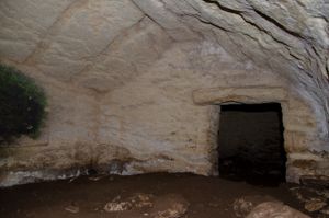
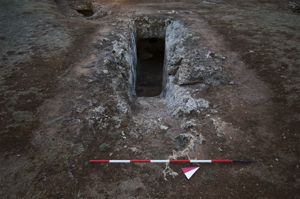
Tomb I, dug into a large isolated boulder, has an elevated entrance on the decking. From the rectangular door, with recesses, you can access the trapezoidal antechamber.
The room has a circular ritual fireplace (diam. m 0.45) and the ceiling sloping to the outside. The planimetric development of the hypogeum is completed with two other rooms: the first, with a hemispherical alcove plan, opens onto the side wall through an elevated quadrangular door; the second subsidiary compartment, always raised and on the back wall, is instead an arched niche.
Tomb II consists of a hemispherical pavilion entrance that leads - through a rectangular door with recesses - into an antecell with a sub-trapezoidal plan. The back wall leads to a second cell, coaxial and semicircular in shape, accompanied by an arched niche.
A third cell, of irregular shape and with an elliptical niche, opens onto the wall d.
Tomb III consists of a pavilion-shaped atrium - with a rectangular door equipped with a recessed door - and an antecell with a subtrapezoidal plan from which you can access the two secondary rooms with a hemispherical plan through quadrangular raised doors.
A 'T' planimetric development can also be seen in Tomb VI.
The reproduction of architectural details of huts can also be seen in Tomb IX, characterized by a single-sloping ceiling, while tombs XI and XVI have hemispherical dimples.
History of excavations
The area has been known since the beginning of the last century thanks to Taramelli's studies.
Bibliography
A. Taramelli, “Buddusò. Various prehistoric monuments, covered fountain of Sos Muros, dolmens of Sos Monumentos and nuraghe Iselle”, in News of the Excavations, 1919, p. 131 ff.;
A. Taramelli, “Sheet 194, Ozieri”, in Archaeological Edition of the Topographic Map of Italy on a scale of 1:100,000, Florence Military Geographic Institute, 1931, p. 19., nos. 54-55; P. Basoli, “Buddusò from prehistory to the Roman age”, in Buddusò. The territory, the economy, the memory, edited by G. Gelsomino, Sassari, Chiarella, 1991, p. 37 ff.
How to get
from Nuoro, take the SS 389 in the direction of the industrial area of Prato Sardo. Cross the SS 131 dir and continue to Bitti without going through any inhabited center. You cross the town and continue in the direction of Pattada on the SS 389 dir for about 1 km until you reach the detour that leads to the Iselle hill; you go up the hill to the top where you will find the hypogeic necropolis and the homonymous nuraghe.
Content type:
Archaeological complex
Archaeology
Usability: unmanaged site
Province: Sassari
Common: Buddusò
Macro Territorial Area: Nord Sardegna
POSTAL CODE: 07020
Address: località Iselle
Update
Where is it
Video
Audio

Comments