Subjects





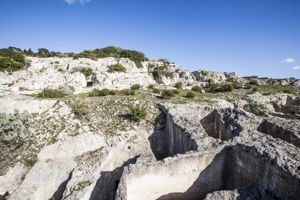
The necropolis of Is Forrus is immersed in a landscape of large volcanic plateaus overlooking narrow valleys, in an area on the border between Marmilla and Sarcidano.
It consists of 18 domus de janas divided into three groups about 200 m apart. The hypogeans of the first group are 5, aligned on the E/O axis; those of the second group, S of the first nucleus, are 3, aligned along the N/S axis; the third group, at m 250 to E, consists of 10 caves that are difficult to access and read.
The burials are of the horizontal projection type with entrances between E and S. A channeling system dug into the rock preserved the interiors of the tombs from the infiltration of rainwater.
The planimetric scheme of the hypogeans has a longitudinal development, with a vestibule that is mostly covered, an anticell and a larger cell (tombs 1, 5, 6); sometimes a second cell communicates with this cell (tombs 2, 3, 4). The vestibules of tombs 7 and 8 are preceded by a long corridor (m 7.40; m 2.80).
The domus have an average area of 3.4 square meters and an average height of 95 cm. The rooms that compose them are rectangular, quadrangular, rounded, elliptical and communicate through rectangular doors. The ceilings are generally flat and join the walls with gentle angles.
The rooms have niches in the walls or open to the floor level: they were probably intended to contain offerings, or, in the case of larger ones, to accommodate separate deposits from the collective ones in the cells. A cup for liquid and solid offerings in honor of the deceased is dug into the floor of the antechamber of Tomb 4.
Particularly interesting is the semi-elliptical cell of Tomb 6, which reproduces a hut. This is attested by the parallel vertical highlights of the walls that simulate the wooden scaffolding supporting the roof.
Tombs 7 and 8 differ from the others, not only because of the already mentioned long access corridors, but also because of the larger size of the rooms. Tomb 8's cell is divided into three parts by two rock diaphragms spared in the floor, which rise by 10 cm.
The situations of the discovery of two small menhirs (residual length cm 50, cm 82) suggest that birch trees were originally placed at the entrance of the hypogeans as symbolic guardians of the dead.
Near the tombs, two large prominences of the rock surface are visible, presumably altars for funerary ceremonies outside the tombs; they have an elliptical shape and have an upper cavity.
At 150 m from the second group of domus, at the foot of Mount Corru Tundu, there is a colossal monolith in trachytic tuff with a truncated top (remaining height m 5.75). The menhir, one of the largest in Sardinia, is strongly tapered, with one face flattened and the other rounded; in this one, three circular cups seem to be identifiable.
Monolith and necropolis, related to each other, were functional to the settlement of Monte Padrillonis, located 700 m north east. The area has returned stone industry and fictilian finds from the late Neolithic period (culture of San Michele, 3200-2800 BC).
History of excavations
Violated from time immemorial, it has never been the subject of scientific excavations.
Bibliography
G. Pinza, “Primitive Monuments of Sardinia”, in Ancient Monuments of the Lincei, 1901, pp. 39-75;
P. Nuvoli, “S. Antonio Ruinas” (Oristano). Loc. Is Forrus, Fontana Caberis, Genn'e Sàlixi”, in The Sardinians. Sardinia from the Paleolithic to the Roman Age, edited by E. Anati, Milan, Jaca Book, 1984, pp. 167-186.
How to get there
The towns of Is Forrus and Monte Corru Tundu can be reached by a municipal road that starts from the outskirts of the town, just before the exit for the Provincial Road that leads to Mogorella.
Content type:
Archaeological complex
Archaeology
Usability: unmanaged site
Province: Oristano
Common: Villa Sant'Antonio
Macro Territorial Area: Central Sardinia
POSTAL CODE: 09080
Address: località Is Forrus
Update
Where is it
Images
Texts
Video


 Facebook
 Twitter
 LinkedIn
 Whatsapp

 Print
Print
 E-mail


Comments