Subjects





In the 17th century, the tower was called “del Zaccurro”. In the following century it was also called 'Iacuri', 'Saccuru', 'Zacuro', or even, in the 19th century, 'Punta del Sacurro' then distorted into 'Punta del Soccoro'. The title of San Gemiliano, which appeared only in 1767, together with other names, such as San Milano, is linked to the nearby country church of San Gemiliano.
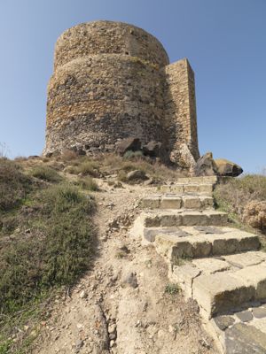
The tower, 42 m above sea level, has a glance of 25 km. It controlled the beach of Orrì and Cea and was in direct contact with the towers of Bari Sardo, in S and with the tower, which no longer exists, of Bellavista, in N/E. The architectural structure of
the tower appears particularly slender. The shape is truncated, 12 m high and only 7 m in diameter; the inner chamber, where the garrison was located, is located about 4 m high and consists of a small domed room of about 13 square meters. This room, also called casamatta, is accessed through a hatch; radially at the entrance there are two troniers or loopholes. To access the Piazza d'Armi, that is, the upper outdoor terrace, a wooden staircase was used that passed through an opening made in the vault of the casemate; on the terrace, you can see, in the opening wall, the gunboats and the compartments of the booths. The tower was built with local granite rocks.
Initially not foreseen in sixteenth-century projects, the tower probably dates back to the first quarter of the 17th century; it is, in fact, recorded in the “Letter on the description of the Island Y Reyno de Sardena”, by Francesco Vico of 1639.
Quoted again in documents from 1720, such as the report of the First Commissioner of Artillery, Factories and Fortifications, Cagnoli, the fortress appears to be in good condition, with only one door missing.
The tower, despite having been designed as a guard, could also be used for light defense; the 1767 report by the Piedmontese Ripol documents the presence of a “warden” (captain of the tower) and two soldiers and an arsenal consisting of six rifles, two pushes and a cannon.
In 1798, the fortress was seriously damaged by lightning and, at a heavy expense, repair work was carried out on the design of the engineer captain Marciot; other renovations were attested in 1798.
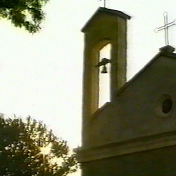
A report from 1828 shows that the tower was in such a disastrous situation that the garrison was forced to stay in the nearby church of San Gemiliano; after this report, the architect Melis was commissioned to carry out a restoration project, completed two years later.
After the suppression, in 1842, of the Royal Administration of the Towers, the tower was under the administration of the “Judicado de Ollastre”, like those of Bari Sardo and Larga Vista; only a few years later, it was abandoned.
History of studies
The tower is included in the main works on coastal fortifications in Sardinia.
Bibliography
E. Pillosu, The coastal towers in Sardinia, Cagliari, La Cartotecnica Typography, 1957;
F. Fois, Spanish towers and Piedmontese forts in Sardinia, Cagliari, La Voce Sarda, 1981;
G. Montaldo, The coastal towers in Sardinia, Sassari, Carlo Delfino, Sassari 1992;
F. Russo, The coastal defense of the Kingdom of Sardinia from the 16th to the 19th century, Rome, Army General Staff, Historical Office, 1992; G. Montaldo, "Forts and Coastal Towers “, in The Architecture fortresses of central-southern Sardinia. Proceedings of the Study Day, Cagliari, October 16, 1999;
M. Rassu, Guide to coastal towers and forts, Cagliari, Artigianarte, Cagliari 2000.
How to get to
Tortolì can be reached via the SS 198 or the Eastern Sardinian road, SS 125. To get to the tower, you must pass the town and continue towards the road (about 4 km), which leads to Marina di San Gemiliano; from the beach, continue for another 500 m and go up the cliff to the tower.
Content type:
Fortified architecture
Province: Nuoro
Common: Tortolì
Macro Territorial Area: Central Sardinia
POSTAL CODE: 08048
Address: via San Gemiliano
Update
Where is it
Images
Author : cultura nuragica
Results 2 of 115851
View All
Video
Results 2 of 49779
View All


 Facebook
 Twitter
 LinkedIn
 Whatsapp

 Print
Print
 E-mail

Comments