Subjects





The monument stands on a granite outcrop, southeast of the mountains of Aggius and northwest of Limbara, in inner Gallura; it enjoys a wide domain over the valleys below.
The monument is a “mixed” nuraghe, that is, characterized by the presence of rooms facing “tholos” and corridors.
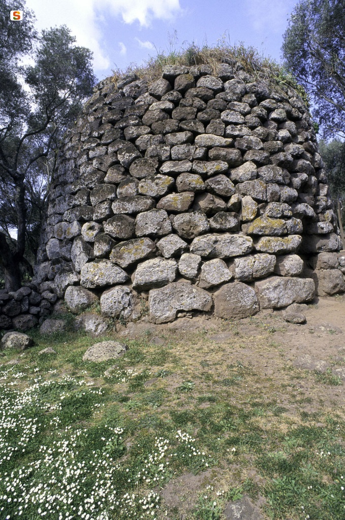
The tower, with an irregular sub-circular plan (diameter m 20 x m 17.70; height max. m 5.30), encompasses some rock outcrops that affect its planimetric development.
The wall structures are made of large and medium-sized polygonal granite blocks, which have just been drafted.
The entrance, facing east-southeast, is surmounted by an architrave equipped with an exhaust window. It leads into a corridor (length m 9.20; width max. m 1.50; height max. m 4.75) that crosses the nuraghe lengthwise until it flows into a large semicircular courtyard (diameter 9.50 m x m 5).
The corridor roof consists of horizontal slabs at a ladder height near the entrance, while it becomes an ogival section in its subsequent development; the floor is paved.
Halfway through the corridor walls, the accesses, not coaxial, of two rooms open: the first room on the right has an ovoid plan (diameter m 4.60 x m 3.60; residual height m 3.80) and a partly collapsed “tholos” roof; the second room, smaller in size and also with an ovoid plan (diameter m 3.80 x m 3.75; residual height m 3.75), has on the back wall a cell with an arched entrance and a sub-circular plan.
On the southwest side of the courtyard, leaning against the tower, a staircase leading to the upper floor is spared: the current state of the structure does not allow an exhaustive reading of the planimetric development of the first floor. However, the remaining wall structures lead to the hypothesis of the original existence of a circular chamber in correspondence with the second compartment below (diameter 7.60 m) and another room on the opposite side.
The nuraghe can be dated between the end of the ancient Bronze and the Final Bronze.
History of excavations
In 1986, Angela Ruju carried out a preliminary excavation and restoration work.
Bibliography
A. Lamarmora, Voyage en Sardaigne ou description statistique, phisique et politique de cette ile avec des recherches sur ses productions naturelles et ses antiquités, 1840 (traduz. V. Martelli, Cagliari 1926-28), p. 96, pl. XIV, 2;
G. Lilliu, "Scoperte e scavi di antichità fattisi in Sardegna durante gli anni 1948 e 1949", in Studi Sardi, IX, 1950, pp. 451-452;
C. Dessì, Singolari nuraghi in Gallura, Sassari, Tip. operaia, 1922, pp. 5-6;
A. Ruju, "Il nuraghe Majori di Tempio", in Nuovo Bullettino Archeologico Sardo, 3, 1986, pp. 9-18.
How to get
There From the town of Tempio Pausania, take the SS 133 to Palau; at km 1.5 turn right into a dirt road and continue for about 450 m until you find the nuraghe on the left.
Structure category: archaeological area or park
Content type:
Archaeological monument
Usability: Open
Province: Sassari
Common: Tempio Pausania
Macro Territorial Area: Nord Sardegna
POSTAL CODE: 07029
Address: SS 133
Telephone: +39 347 2995933 +39 320 3060634
E-mail: info@gallurarcheologica.com balaressas@legalmail.it
Website: www.gallurarcheologica.com
April - October
Monday - Tuesday - Wednesday - Thursday - Friday - Saturday - Sunday
9:30 AM - 7:00 PM
Information on tickets and access: Reservation: none from April 1st to October 31st. Reservations are required from November 01 to March 31.
Access mode: For a fee
Tickets :
Update
Services
 Teaching room
 Bookshop
 Guided tours
Where is it
Video


 Facebook
 Twitter
 LinkedIn
 Whatsapp

 Print
Print
 E-mail
.jpg)


Comments