The archaeological area develops along the slopes of a granite promontory and on the surrounding plain, near the bay of Santa Reparata, on the north coast of Gallura.
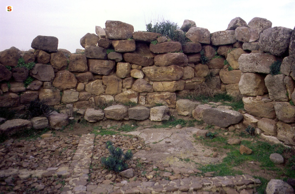
The complex includes a nuraghe with an antewall, a village, a tomb of giants, taphones and rock shelters.
The nuraghe, located at the highest point of elevation, uses the rocky levels to develop on staggered levels. Invaded by the collapse, it presents mixed elements of “corridor” and “tholos” architecture. The central keep is surrounded by an antemural with a curtain and two towers (the one transformed in post-medieval times into a lime kiln). A monumental entrance opens on the NW side of the curtain.
The collapse does not allow us to read the development of the environments inside the wall.
The village, which in 1967 had 36 huts, today only partially visible, extends along the slope and into the plain to the E and S of the nuraghe.
The excavated area, in E shape, has highlighted small blocks of buildings that are tangled or separated by narrow passages or dead ends.
The huts, generally curvilinear, adapt to the rock morphology, often incorporating the outcrops, and have double wall walls; the blocks, just sketched or rough, are arranged in regular rows and tied with mud mortar (hut 1: h walls m 2.20-2.30).
The conical roofs were held by beams of beams and joists to which other transverse wooden elements were attached. These supported a network of bundles of marsh reeds converging towards the center and covered with a layer of clay mortar that ensured their insulation. Other plant bundles blocked by small limestone slabs were then superimposed.
The floors were made of clay or made use of natural rock.
The village shows phases of renovation and redistribution of spaces, with the addition of rooms for specific domestic uses (hut 2, production of ceramics).
The finds found give an overview of the village's economy between the 14th and 9th centuries BC: containers for food that attest to agricultural activities, elements of obsidian sickles for harvesting, containers for boiling and processing milk, boiled milk and multiperforated bowls for cheese production. There are also numerous containers for food preparation and skewer supports. Food leftovers indicate the consumption of cattle, sheep, goats, birds, patella, fish.
The tomb of giants, of which only the foundations advance, is located SE of the village, on the edge of the slope. Once majestic, it consists of an elongated tomb with an apsidal end and a semicircular exedra. The masonry was probably in rows.
The grave corridor, trapezoidal (long. cm 6.10; width. m 1.10-0.85) faces the entrance to SE and is delimited by two jambs on which the lintel originally rested.
The space in front of the entrance to the exedra is paved with flat slabs, the remaining parts with cobblestone.
The excavation of the corridor has returned about 50 burials in primary deposition, male and female. At the bottom, the skeletal remains were accumulated disorderly, evidently due to the impetus produced by the need to create space for new burials.
Collective funeral meals were probably held in the space of the exedra, with the subsequent rite of the shredding of used objects.
The materials found attest to the use of the tomb between the 14th and 10th centuries BC.
About 60 km SE there is a circular structure perhaps linked to the ritual that preceded the burial in the tomb of giants.
The taphones and ravines that open into the granite boulders on the O and SW sides of the promontory were used in the Nuragic era as shelters and homes and as burial places.
History of excavations
It was investigated for the first time by Michele Careddu, in 1967, as part of a thesis research. The tomb of giants was excavated in the eighties; the excavations of the village are underway, by Angela Ruju.
Bibliography
A. Ruju, "Una finestra sulle Bocche. Il complesso di Lu Brandali (Santa Teresa Gallura)", in Almanacco Gallurese, 2002-03, p. 87 ss.;
A. Ruju, Il complesso nuragico di Lu Brandali e i monumenti archeologici di Santa Teresa Gallura. Sassari, C. Delfino, 2005 (Sardegna archeologica. Guide e itinerari; 37).
How to get
From Olbia, the Isola Bianca port area, to Arzachena, take the SS 125 to the junction for Palau; at the crossroads you turn south on the SS 133, which connects directly to the SS 133 bis to Santa Teresa Gallura. Upon entering Santa Teresa Gallura, take Via Nazionale, at the traffic lights turn left in the direction of Capo Testa. The entrance to the archaeological site, with outdoor and internal parking, is about 1 km away.
Structure category: archaeological area or park
Content type:
Archaeological complex
Archaeology
Usability: Open
Province: Sassari
Common: Santa Teresa Gallura
Macro Territorial Area: Northern Sardinia
POSTAL CODE: 07028
Address: SP 90 - via Capotesta, s.n.c.
Telephone: +39 349 8347698 +39 347 7412166 +39 392 0547979
E-mail: info@lubrandali.it cooltourgallura@gmail.com info@santateresaturismo.it amministrazione@santateresaturismo.it
Website: www.lubrandali.it www.santateresaturismo.it/sito-archeologico-lu-brandali
Facebook: www.facebook.com/cooltour.gallura
Twitter: twitter.com/CoolTourGallura
Special openings: Upon reservation, it is possible to visit the site outside normal access hours.
Information on tickets and access: To always have up-to-date information on schedules, ticket costs, cumulative offers and additional services, it is recommended to visit the dedicated page on the operator's website.
Access mode: For a fee
Tickets :
Services information: Guided tours from April to October at the following times: 09:30-10:30 - 11:30-16:30 - 17:30; from October 1 to March 31, guided tours must be booked in advance.
Update
Services
![]() Guided tours
Guided tours
![]() Facilitated physical accessibility for visitors with specific needs
Facilitated physical accessibility for visitors with specific needs
Where is it
Images
.JPG)
Year : 1930
Results 2 of 122452
View All
Comments