The bridge is on the Mannu di Ozieri river, in the center of the Monteacuto valley, limited to N/E by Limbara and S by the mountains of Alà dei Sardi and Pattada, and marked by a dense hydrographic framework of rivers and swamps.
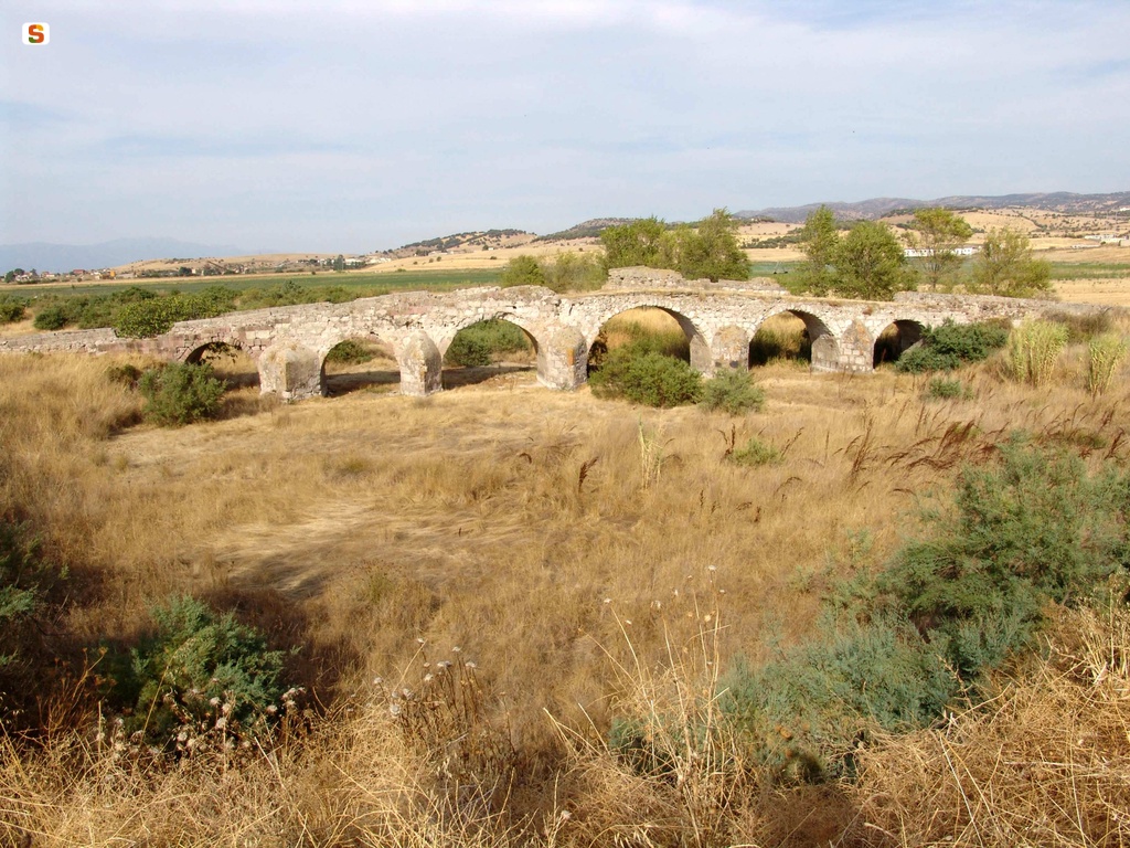
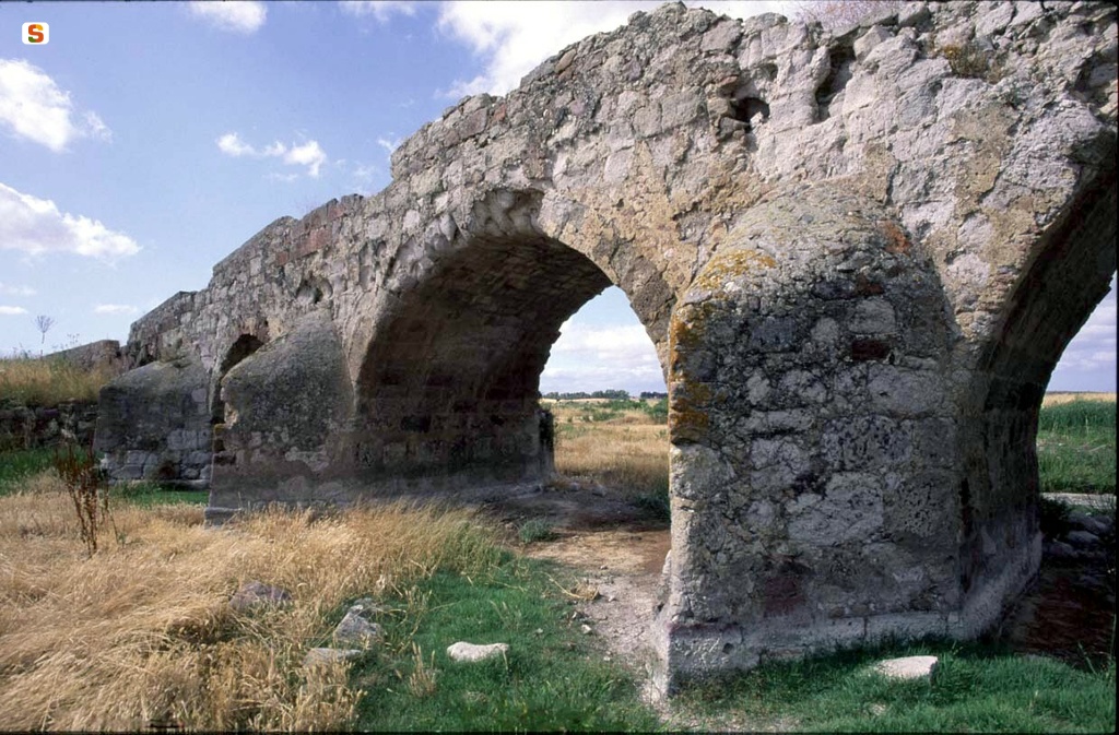
Known locally as “Pont'Ezzu” (old bridge), it exceeds 90 m in length. It is divided into six frames, with decreasing rays from the center to the sides, and has a square wall of basalt and andesite ashlars. Inside, but also in the surviving parts of the tower, there is a more regular wall work with basalt blocks. In the space between the edge of the arches, there is a robust cement conglomerate that supports the decking about m 3 wide. At the pillars, the spurs that counteracted the force of the river and the wear and tear exerted by the current are well preserved.
The bridge was located along the road that connected Cagliari with Olbia, known thanks to written and material sources.
On this road, in the Monteacuto Valley, there were five other bridges. The first, from O, is that of Iscia Ulumu, in the town of San Luca (Ozieri). Partly preserved, it made it possible to cross the confluence between the Mannu di Ozieri river and the Buttule river with a double arch. A couple of kilometers further E is the Pont'Ezzu.
The third bridge was also six-arched, near the Badu de sa Feminedda (Ozieri), located less than 3 km east of the previous one. Of the structure, the cement conglomerate piles covered with volcanic blocks are preserved.
A fourth bridge was located on the slopes of Castro Hill (Oschiri) near the center of Luguidune. After passing this settlement, the road, after a few kilometers to E, crossed the Mannu river of Berchidda.
Here, in the Silvani region, at the base of the hill that houses the remains of the castle of Monte Acuto, there is a fifth bridge still visible in its foundations. From this point, as several milestones attest, the road continued towards Monti as far as Olbia.
The existence of a sixth bridge, the 'Ponte di San Leonardo de Orvei', can be deduced from the descriptive reports of the duchy of Monteacuto (Sardinian fiefdoms of the Spanish family of Oliva), from the 18th century. Probably the structure, referring to the connecting road between Luguidune and the center of Gemellas (Perugas), is to be located N of Tula. The bridge is visible only in summer, when the level of the Coghinas reservoir drops, in the N/O zone of the Monteacuto Valley.
The small distance between the bridges (a few kilometers as the crow flies) and the presence of fords (there are about twenty in the Monteacuto Valley) attests to the very long life span of the road system set up by the Romans.
However, it can be assumed that the road network was established during the Republican period and gradually perfected and corrected in the following centuries.
The functioning of the system and the subsequent continuity of use of the valley floor routes is certainly the basis for the long-term preservation of bridges. Still in the Middle Ages, on the Pont'Ezzu di Ozieri, as on the others, the roads that came from the mountain territories to the S of Ozieri had to converge, but also the roads that from O, in addition to Ardara capital of the Kingdom of Torres, touched the centers of Ploaghe and Bisarcio, headquarters of the homonymous dioceses.
In the E part of the valley there was Castra, seat of the medieval diocese of the same name, to be located near the church of Santa Maria di Castro (Oschiri). A few kilometers E from this was the castle of Monte Acuto (Berchidda), founded in the 12th century by the judges of Torres. In O, in the second half of the 14th century, the castle of Orvei (Ozieri) was built by the Arborea. This fortress is located less than 10 km N/E from Pont'Ezzu, on the top of Mount San Leonardo.
History of excavations
The bridge has not been the subject of archaeological excavation.
Bibliography
F. Amadu, Ozieri and its territory from Neolithic to Roman times, Cagliari, Fossataro, 1978, pp. 232-233;
“Ozieri”, in L'Antiquarium Arborense and the Civic Archaeological Museums of Sardinia, curated by G. Lilliu, Sassari, Banco di Sardegna-Cinisello Balsamo, A. Pizzi, 1988, pp. 71-92;
F.G.R. Campus, “The medieval human settlement in the territory of Oschiri (Sassari): training processes and dynamics of transformation”, in Oschiri, Castro and the Eastern Logudoro, curated by G. Meloni-P.G. Spanu, Sassari, Carlo Delfino, 2004, pp. 151-188; A. Mastino-P.G.
Spanu-R. Zucca., “The territory of Oschiri from the Roman period to the Byzantine Age”, in Oschiri, Castro and the Eastern Logudoro, edited by G. Meloni, P. G. Spanu, Sassari, Carlo Delfino, 2004, pp. 77-99; J.M. Poisson, “Ozieri (Sassari).
Locality of S. Leonardo. First archaeological research campaign at the Urvei site”, in Bulletin of Archaeology, 1991, 10, pp. 135-136;
P.G. Spanu, “The Roman Age”, in Il Monte Acuto. Itinerant Museum of the Territory, Muros, Stampacolor, 2002, pp. 56-57.
How to get
From the SS 131 at the height of Mores in the direction of Sassari, turn right up the SS 128 bis and proceed directly to Ozieri. You leave the town and continue to San Nicola along the SS 132 to the junction. From that point, continue for another km, leaving the town of San Nicola on the d.
Content type:
Archaeological monument
Archaeology
Usability: unmanaged site
Province: Sassari
Common: Ozieri
Macro Territorial Area: Nord Sardegna
POSTAL CODE: 07014
Address: località San Nicola
Update
Where is it
Images


Comments