The nuraghe is located on a basaltic plateau, on the slopes of Mount Manai, in a dominant position on the Abbasanta plain, in the Marghine region, in central-northern Sardinia.
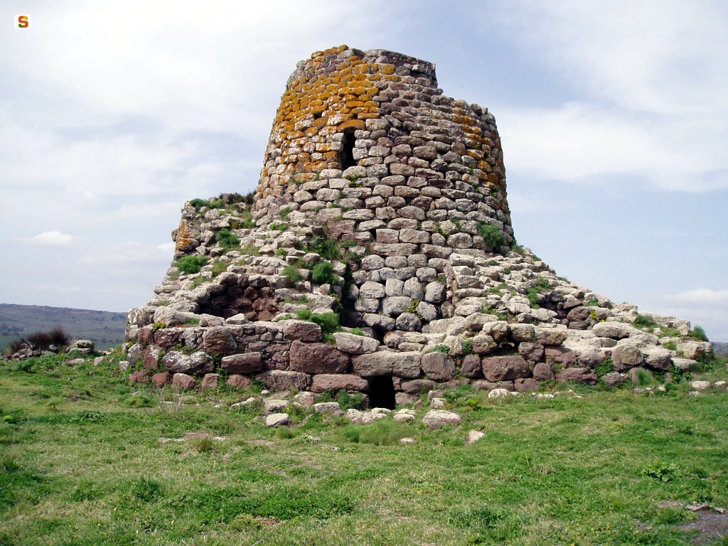
The building, one of the best known on the island, is of a complex type, consisting of a central tower and a quadrilobed bastion with an open-air courtyard.
It was defended by an antemural, taken over by General Della Marmora, which is currently barely legible on the countryside.
The bastion (height 8.80 m) includes four towers connected by curtain walls, with a concave-convex profile, built with freshly sketched basalt blocks and arranged on horizontal courses.
The bastion is accessed through a quadrangular entrance oriented to SE that leads to a short trapezoidal corridor, connecting to the semi-elliptical courtyard. The entrances to the central tower and the secondary front towers open on the walls of the latter.
The secondary tower B, accessible through a short trumped passage equipped with a niche in the wall d. (restored in ancient times), has a circular plan (diameter 3.30 m; height 3.20 m) and a loophole, in line with the entrance and raised.
A large trapezoidal entrance, raised above the floor, opens into the SW wall of the room and leads to a small shelf with three large niches and slits. From the shelf, turning to the d., a staircase departs, parallel to the curtain wall of the prospectus, which, almost at the height of the courtyard, turns sideways and passes over the entrance that leads to tower B and then onto the bastion.
Tower C, with a circular plan (m 4 x m 4.10; height m 5), accessible directly from the courtyard through an arched entrance, shows, in s., a niche-loophole and three frames and, on the d., a second raised niche with the function of a cabinet.
The bastion includes towers D and E, both to be excavated, but almost completely destroyed.
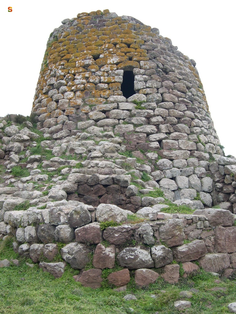
The central tower A (diameter 9 m at the height; height 15 m) is built with blocks worked with some care and installed in regular horizontal rows.
The entrance, oriented to SE and surmounted by a lintel with an exhaust window, leads into a flat aisle on whose walls are open a niche (to the s) and the staircase (to the d.).
The room on the ground floor, slightly flattened in plan (diameter 5.05 m x 5.80 m; height 9.60 m) shows three niches arranged in a cross.
The room on the first floor, more regular than that on the ground floor, has a circular plan (diameter 3.50 m; height 4.80 m) without subsidiary rooms and illuminated by a trapezoidal window with an arched lintel.
The profile of a third chamber (diameter 3.10 m) can still be read when the tower stands out.
Around the monument, for a large area, the remains of the town are preserved, whose use continued in Roman and early medieval times.
History of excavations
Detected by Lamarmora (1860) and Mackenzie (1918), the nuraghe was excavated between 1979 and 1981.
Bibliography
A. Della Marmora, Voyage en Sardaigne ou description statistique, phisique et politique de cette ile avec des recherches sur ses productions naturelles et ses antiquités, II (Antiquités), Paris, A. Bertrand-Torino, J. Bocca, 1840, pp. 43, 82-84, 95, 97, 112, fig. 1-11, pl. XII;
E. Pais, “Sardinia before Roman rule. Historical archaeological study”, in Proceedings of the Accademia Nazionale dei Lincei, VII, CCLXXVIII, 1880-81, p. 281, tav. II, 8;
A. Taramelli, “Sheet 205, Capo Mannu; Sheet 206, Macomer” in Archaeological Edition of the Map of Italy at 100,000, 48, Florence, Military Geographic Institute, 1935, p. 59;
E. Contu, “Nuragic Architecture”, in Ichnussa: Sardinia from its origins to the classical age, Milan, Scheiwiller, 1981, pp. 3-175; A. Moravetti, “Preliminary note to the excavations of the Nuraghe S. Barbara di Macomer”, in New Sardinian Archaeological Bulletin, 3, 1986,. 49-113;
A. Moravetti, Archaeological Research in the Marghine-Planargia. Il Marghine - Monuments, Part One. Sassari, C. Delfino, 1998 (archaeological Sardinia. Studies and monuments; 5), pp. 101-107, figs. 156-162;
A. Moravetti, Archaeological Research in the Marghine-Planargia. Planargia — Analysis and Monuments, Part Two. Sassari, C. Delfino, 2000 (archaeological Sardinia. Studies and monuments; 5).
Structure category: archaeological area or park
Content type:
Archaeological monument
Archaeology
Usability: Open
Province: Nuoro
Common: Macomer
Macro Territorial Area: Central Sardinia
POSTAL CODE: 08015
Address: SS 129 bis
Telephone: +39 347 9481337 +39 0785 743044 +39 0785 70475
E-mail: info@esedraescursioni.it esedraescursioni@libero.it
Website: www.esedraescursioni.it/escursioni-servizi/sistemamusealemacomer
Facebook: www.facebook.com/esedraescursioni
January - December
Friday - Saturday - Sunday
10:00 AM - 5:30 PM
Information on tickets and access: Tickets for guided tours can be purchased directly at the Filigosa Necropolis site. Reservation required for the afternoon.
Access mode: For a fee
Tickets :
Services information: The guided tour is included in the ticket price.
Update
Services
![]() Guided tours
Guided tours
Where is it
Macomer, Nuraghe Santa Barbara Images number: 1
Images
![Cagliari, cortile della torre di S. Pancrazio, 1995 : [notizie, scavi e lavori sul campo, schede 1994-95]](data:image/png;base64,iVBORw0KGgoAAAANSUhEUgAAAAEAAAABCAQAAAC1HAwCAAAAC0lEQVR42mNkYAAAAAYAAjCB0C8AAAAASUVORK5CYII=)
Comments