Subjects





The Sos Nurattolos complex is located at the foot of the tip of Senalonga in a dominant position on the Buddusò plateau and the surrounding valleys.
The site includes a sacred spring, a small temple “in Megaron” - both with enclosures - and some huts, one of which is attached to the small temple.
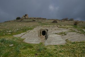
Going up the slope that leads to the top of the hill, you find the fountain, consisting of a circular body (diameter 6.25 m) built with large boulders arranged polygonal in the outer wall and with square blocks in the internal structures.
The building contains a rectangular vestibule (length m 5; width m 2.60; height cm 90) which is accessed through an entrance oriented in S (width cm 70).
At the center of the back wall of the vestibule, there is the entrance, arched with a drain compartment, of the quadrangular cell with an ogival section, which protects the spring vein.
The small compartment has a scalar cover descending towards the arcuate bottom. The masonry is made of medium-sized granite boulders, arranged in regular rows with the use of reinforced wedges.
The building is surrounded by the usual circular sacred enclosure (m 11.30 in NE-SO, m 10.00 in SE-NO) made of polygonal work (thickness m 0.70/1.20) and accessible through a side entrance (width m 1.10) facing S and equipped with steps.
Not far from the well, a large circular hut (inner diameter 8.40 m; thickness 1.40 m) with an arched entrance facing SE (width 0.80 m) is built. The structure is made of stones, generally small in size, unprocessed and superimposed without special care.
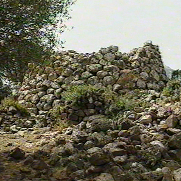
On the top of the hill is the small rectangular temple “a Megaron”, whose wall structures are still preserved for a considerable height.
The building is built inside an elliptical enclosure (diam. m 16 x 13) with an entrance oriented to E (width m 0.90).
The building - built with granite boulders arranged in regular rows - has a rectangular plan (m 6.15 x 4; height m 2) with an arched entrance oriented to NO (width m 0.90; height m 1.20). The small temple is characterized by the presence on the back of the typical extension of the side walls.
Inside, the walls do not show a significant feature: it has been assumed that the lateral wall structures originally supported a double-sloped wooden roof.
Next to the small temple, it is a rather unique building: it is a circular building (diameter m 5.20; height m 1) that encloses inside a second room of the same shape (diameter m 2.30) tangent on the SE side and with walls in a strong projection. The two buildings do not seem to have entrances.
A short distance away, at a higher altitude, the excavation work has made it possible to highlight a new, large communal hut, whose walls are equipped with a seat at the base, similar to what was documented in the so-called “meeting huts” found in numerous nuragic villages.
History of excavations
Discovered in the Sixties, in recent years it has been affected by excavation activities (Paola Basoli) and by works to organize the area.
Bibliography
A. Baltolu, Alcuni monumenti inediti dell'altopiano di Buddusò e Alà dei Sardi (Sassari)", in Studi Sardi, XXII, 1971, pp. 38-98;
G. Lilliu, "L'oltretomba e gli dei", in Nur. La misteriosa civiltà dei Sardi, Cinisello Balsamo, A. Pizzi, 1980, pp. 110, 114-116;
V. Santoni, "Il segno del potere", in Nur. La misteriosa civiltà dei Sardi, Cinisello Balsamo, A. Pizzi, 1980, p. 184;
E. Contu, "Il nuraghe", in La Civiltà nuragica, Milano, Electa, 1985, pp. 124, 126, fig. c a p. 139, pp. 130, 141, tav. X;
G. Lilliu, La civiltà dei Sardi dal paleolitico all'età dei nuraghi, Torino, Nuova ERI, 1988, pp. 393, 395, 537;
A. Sanna, "Nuove osservazioni su alcuni pozzi sacri della Sardegna settentrionale", in Per una storia dell'acqua in Sardegna. Atti del terzo Convegno internazionale di studi geografico-storici, Sassari, 1990, pp. 12-17;
G. Ugas, "Considerazioni sullo sviluppo dell'architettura e della società nuragica", in Sardinia in the Mediterranean: a footprint in the sea. Studies in Sardinian archaeology presented to Miriam S. Balmuth, a cura di R.H. Tykot e T.K. Andrews, Sheffield, Sheffield Academic Press, 1992, p. 230.
How to get there
From the center of Alà, follow the signs that indicate the archaeological area of Sos Nurattolos or, alternatively, the one for the church of San Francesco. We proceed first flat along the paved road, taking care to keep the road at a crossroads, then the route climbs along an asphalted road, uphill, until it reaches the pitch at the reception center of the archaeological area, from which the path with steps that leads to the top (at 1000 m above sea level), where the nuragic complex is located, starts.
Content type:
Archaeological complex
Archaeology
Usability: unmanaged site
Province: Sassari
Common: Alà dei Sardi
Macro Territorial Area: Nord Sardegna
POSTAL CODE: 07020
Address: località Punta di Senalonga
Update
Where is it
Alà dei Sardi, Sos Nurattolos Complex Images number: 3
Video


 Facebook
 Twitter
 LinkedIn
 Whatsapp

 Print
Print
 E-mail


Comments