Subjects





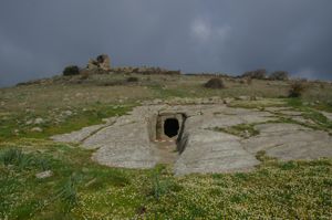
The monument is located in the town of Mesu de Roccas, on a rocky ridge, in a dominant position over the Riu Mannu valley, in the Logudoro region of northwestern Sardinia.
The Mola Front is an interesting “corridor” nuraghe, the only one known so far with a rectangular plan (length 16.20 m; width 12.00 m; height res. m 8.00).
It orients the main side along the N-S axis and shows the entrance to S.
It is built at the base with large blocks of crudely sketched limestone and in the upper parts with smaller boulders superimposed and reinforced with wedges.
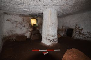
The entrance, arched (width 1.20 m; height 2.00 m) and opened in a slightly decentralized position on the short S side, leads to a long longitudinal corridor (length 12.00 m; width 1.20 m; height 2.50 m); four side niches (two in the d and two in the s) open up on this with vertical walls and upper flat slabs.
The first niche in s. (depth m 3.00; width m 1.60/1.40; height m 2.00) shows on the wall a small raised closet (width m 0.50; depth m 1.00; height m 0.40).
The first square (depth m 2.00; width m 1.00), faced with the previous one, acts as the entrance, in the outer wall, to the staircase (width m 1.00).
The other two niches are not in axis: the floor space has a semi-elliptical plan (depth 2.40 m; width 1.00 m; height 1.50 m); the d-shaped, semicircular one is narrower (depth 1.20 m; width 1.20 m).
Corridor and niches are flatlined with large horizontal slabs; the section of the rooms is rectangular.
The staircase, which leads to the upper floor, runs parallel to the E side of the building until it turns at a right angle at the N end of the path. On the upper floor, there is a rectangular room (length 8.00 m; width 3.00 m; residual height 2.50 m), now open air, decentralized from the corridor below.
The nuraghe probably dates back to the Middle Bronze Age.
History of excavations
The nuraghe has been known in the history of studies since the beginning of the last century.
Bibliography
F. Préchac, “Notes sur l'architecture des Nuraghes de Sardaigne”, in Mélanges d'Archéologie et d'Histoire publiés par l'École française de Rome, XXVIII, 1908, pp. 142-148, 154, 150, 161, 108, figg. 2-7;
A. Taramelli, “Sheet 193: Bonorva”, in Archaeological Edition of the Italian Charter 100,000, 37, Florence, Military Geographic Institute, 1940, p. 185, n. 9; G. Lilliu, I bulri, I turri, torri prehistoric buildings of Sardinia, Cagliari, La Zattera, 1962, pp. 136-137, figg. 12-13;
G. Lilliu, The Nuragic Civilization, Sassari, Carlo Delfino, Sassari 1982, pp. 16-17, figg. 5, 13;
E. Contu, “Nuragic Architecture”, in Ichnussa: Sardinia from its Origins to the Classical Age, Milan, Scheiwiller, Milan, 1981, pp. 108, figg. 106-108; E. Contu, “The Nuragic Architecture”, in The Nuragic Civilization, Milan, Electa, 1990, p. 45 ff., tav. IVB.
How to get there
Leave the town of Thiesi in the direction of Ittiri. After passing the Romana junction, after 2.8 km, there are two gates facing each other on opposite sides of the road. You leave the car and enter the one on the left; you go up the slope until you reach, among the vegetation, the nuraghe.
Content type:
Archaeological monument
Archaeology
Usability: unmanaged site
Province: Sassari
Common: Thiesi
Macro Territorial Area: Nord Sardegna
POSTAL CODE: 07047
Address: SS 131 bis - località Mesu de Roccas
Update
Where is it
Texts

Author : De Marchi, Giulio <1890-1972>
Year : 1950
Year : 1982
Results 2 of 304163
View All


 Facebook
 Twitter
 LinkedIn
 Whatsapp

 Print
Print
 E-mail
Comments