Subjects





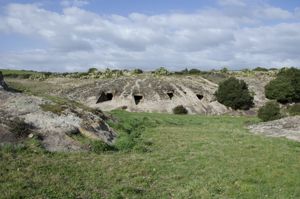
The necropolis is located in Partulesi on a large front of tuff rock, in Monte Acuto, a region of inland northern Sardinia.
The complex comprises about thirty domus de janas spread over different levels. It is not unlikely that originally the number of tombs was greater. The hypogeums are accessible in most cases through a corridor ('dromos') dug into the rock.
The planimetric system is almost always multicellular with the arrangement of the rooms in the “T” pattern modified by subsequent extensions.
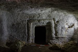
The rooms, generally with a straight planimetric profile, have well-finished walls on which niches (tombs I, XIV, XXIV-XXV) or doors decorated with framed recesses (tombs IX, XI, XIV; XXVI) or surmounted by relief lintels (tombs XVIII, XXVI); in at least two cases counters are spared at the base of the walls (tombs II, XIX).
Notable among all are Tomb XIX, the best preserved, Tomb XXV, due to the presence of numerous cups, and especially Tomb XIV, which in the Bronze Age was transformed into a tomb “with an architectural façade”. Tomb XIV - now communicating with the adjacent tomb XV - consists of two rooms with an irregular quadrangular plan arranged deep on a common axis. The burial is characterized by the presence on the forehead of a curved stele (height 2.75 m; width 0.60 m at the top), a typical element of the tombs of giants that in the Sassari area is often reproduced on rock fronts that house hypogeic burials (so-called “nuragic domus”). Tomb XXV, with its rather simple layout consisting of two cells with a niche, has a unique concentration of cups dug into the walls.
The necropolis can be dated between the final Neolithic (culture of Ozieri, 3200-2800 BC) and the Eneolithic.
History of the excavations
The necropolis has been known since Taramelli reports.
Bibliography
A. Taramelli, "Foglio 193, Bonorva", in Edizione della Carta Archeologica d'Italia, Firenze, Istituto Geografico Militare, 1940, p. 10, n. 41;
F. Galli, Archeologia del territorio: il Comune di Ittireddu (Sassari), collana "Quaderni della Soprintendenza ai Beni archeologici per le province di Sassari e Nuoro", 14, Sassari, Chiarella, 1983, p. 19 ss., n. 6, tavv. XIV-XXI;
F. Galli, Ittireddu. Il museo e il territorio, collana "Sardegna Archeologica. Guide e Itinerari", 14, Sassari, Carlo Delfino, 1991, pp. 9, 31-32, figg. 23-24.
How to get
There From the town of Ittireddu, take the municipal road in the direction of the church of Sant'Elena. After passing the church (less than a km from the town), after about 250 meters, you will find the gate of the archaeological area on the right: a small concrete road, after about 300 meters, leads to the base of the hill where the tombs open.
Content type:
Archaeological complex
Archaeology
Usability: unmanaged site
Province: Sassari
Common: Ittireddu
Macro Territorial Area: Nord Sardegna
POSTAL CODE: 07010
Address: strada comunale Mandra Ponte Ezzu - località Partulesi
Update
Where is it
Texts
![Nuovi scavi nella tomba B e scoperte nelle tombe 22., C e V della necropoli : [Alghero - Sassari, Loc. Aanghelo Ruiu]](data:image/png;base64,iVBORw0KGgoAAAANSUhEUgAAAAEAAAABCAQAAAC1HAwCAAAAC0lEQVR42mNkYAAAAAYAAjCB0C8AAAAASUVORK5CYII=)
Author : Demartis, Giovanni Maria
Author : Demartis, Giovanni Maria
Results 2 of 1294658
View All
Video
Audio


 Facebook
 Twitter
 LinkedIn
 Whatsapp

 Print
Print
 E-mail

Comments