Subjects





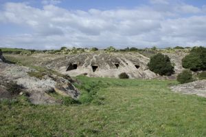
The burials are dug in a rocky outcrop in the town of Sa Ide, an area rich in valleys and crossed by the Rio Giunturas and the Rio de Maniga, in Anglona, a region of northern Sardinia.
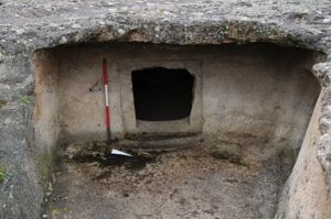
The necropolis, at present, consists of three hypogeums, characterized by the presence of a long dromos, a large atrium - oriented to E/SE - and several rooms arranged according to a “T” planimetric pattern.
Tomb I, seriously damaged, has a centripetal planimetric development.
The large atrium, with the entrance oriented to E, has traces of red plaster on the walls on a white background, a small niche and a bowl.
From the anticell with a rectangular plan (width m 1.75; length m 1.10) you can access the central cell with an irregular quadrangular plan (diameter m 4; depth m 3.20); this leads to six secondary cells raised and arranged in a beam. In some of them, traces of red color are preserved on the walls.
The ceiling has - sculpted in relief - the representation of a double-sloped roof, with a central beam from which 14 joists branch off on each side.
The entrance wall and the opposite wall are decorated with a composition of double horns surmounting the door.
Other ornamental motifs decorate the lower part of the walls: frames, pilasters, two rectangular boxes bordered by frames, a sort of seat with a semicircular backrest.
Tomb II, with a centripetal planimetric development, consists of a long “dromos” from which you can access the quadrangular antechamber and then to the central compartment, where five subsidiary rooms arranged in a beam overlook.
Four cells were dug lengthwise in the upper wall of the 'Dromos'.
Also on the south side of the “dromos”, near the entrance to the anticella, a second access opens to a group of three quadrangular coaxial rooms.
Tomb III, with a cruciform planimetric layout, also has a long corridor with a dividing septum at the entrance. From the entrance, there is access to a central rectangular chamber and then to a coaxial cell with an ovoid plan; on the s. side, a secondary compartment with an elliptical plan opens, while on the d. side you can see a series of small subsidiary environments that, with a circular pattern, connect with the d. side of the “dromos”.
Excavation investigations have been able to ascribe the first installation of the necropolis to the final Neolithic (Culture of San Michele), with subsequent reuse of the hypogeans during the Copper Age (culture of the Campaniform Vase), in the ancient Bronze (culture of Bonnanaro) and in Roman times.
History of excavations
The complex was excavated in 1998-99 by Giuseppe Pitzalis.
Bibliography
E. Contu, “Notiziario-Sardegna”, in Rivista di Scienze Preistoriche, XXIII, 1968, p. 427; G. Tanda, Prehistoric Art in Sardinia. The sculpted bullfighting figurations of the Algherese in the framework of the figurative representations of the Sardinian hypogeans at “domu de janas”, series “Notebooks of the Superintendence for Archaeological Heritage of Sassari and Nuoro”, 5, Sassari, Dessì, 1977, p. 45, sch. 26, 28;
G. Tanda, The Art of the Domus de Janas in the images of Jingeborg Mangold, Sassari, Chiarella, 1985, pp. 138-141; G. Pitzalis, “The Necropolis of Su Murropolis of Su Murropolis In Chiaramonti”, in Gallurese Almanac, 8, 2000-01, pp. 94-102.
How to get
From Sassari in the direction of Olbia, take the SS 594 to Tempio until the junction for the hamlet of Su Murrone; continue for about 2 km: the tombs are on the right side of the road.
Content type:
Archaeological complex
Archaeology
Usability: unmanaged site
Province: Sassari
Common: Chiaramonti
Macro Territorial Area: Nord Sardegna
POSTAL CODE: 07030
Address: località Su Murrone
Update
Where is it
Video
Audio


 Facebook
 Twitter
 LinkedIn
 Whatsapp

 Print
Print
 E-mail


Comments